You are here: Home > Network List > TA - USArray Transportable Network (new EarthScope stations) Stations List
> Station X29A Tulia, tX, USA > Earthquake Result Viewer
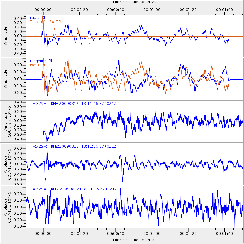
X29A Tulia, tX, USA - Earthquake Result Viewer
*The percent match for this event was below the threshold and hence no stack was calculated.
| Earthquake location: |
Catamarca Province, Argentina |
| Earthquake latitude/longitude: |
-27.9/-66.7 |
| Earthquake time(UTC): |
2009/08/12 (224) 18:00:52 GMT |
| Earthquake Depth: |
174 km |
| Earthquake Magnitude: |
5.5 MW, 5.3 MB, 5.5 MW |
| Earthquake Catalog/Contributor: |
WHDF/NEIC |
|
| Network: |
TA USArray Transportable Network (new EarthScope stations) |
| Station: |
X29A Tulia, tX, USA |
| Lat/Lon: |
34.45 N/101.70 W |
| Elevation: |
1039 m |
|
| Distance: |
70.3 deg |
| Az: |
329.746 deg |
| Baz: |
147.343 deg |
| Ray Param: |
$rayparam |
*The percent match for this event was below the threshold and hence was not used in the summary stack. |
|
| Radial Match: |
48.423542 % |
| Radial Bump: |
400 |
| Transverse Match: |
33.976204 % |
| Transverse Bump: |
400 |
| SOD ConfigId: |
2622 |
| Insert Time: |
2010-03-05 23:11:33.192 +0000 |
| GWidth: |
2.5 |
| Max Bumps: |
400 |
| Tol: |
0.001 |
|
Signal To Noise
| Channel | StoN | STA | LTA |
| TA:X29A: :BHZ:20090812T18:11:16.374021Z | 3.3522806 | 2.5414553E-7 | 7.581272E-8 |
| TA:X29A: :BHN:20090812T18:11:16.374021Z | 1.4719428 | 1.2336818E-7 | 8.381316E-8 |
| TA:X29A: :BHE:20090812T18:11:16.374021Z | 1.1480823 | 1.7049912E-7 | 1.4850777E-7 |
| Arrivals |
| Ps | |
| PpPs | |
| PsPs/PpSs | |


