You are here: Home > Network List > UO - University of Oregon Regional Network Stations List
> Station PINE Pine Mountain Observatory, OR > Earthquake Result Viewer
PINE Pine Mountain Observatory, OR - Earthquake Result Viewer
| Earthquake location: |
Peru-Ecuador Border Region |
| Earthquake latitude/longitude: |
-2.7/-75.3 |
| Earthquake time(UTC): |
2017/04/18 (108) 17:49:55 GMT |
| Earthquake Depth: |
11 km |
| Earthquake Magnitude: |
6.0 Mww |
| Earthquake Catalog/Contributor: |
NEIC PDE/us |
|
| Network: |
UO University of Oregon Regional Network |
| Station: |
PINE Pine Mountain Observatory, OR |
| Lat/Lon: |
43.79 N/120.94 W |
| Elevation: |
1916 m |
|
| Distance: |
61.8 deg |
| Az: |
324.008 deg |
| Baz: |
125.845 deg |
| Ray Param: |
0.060668852 |
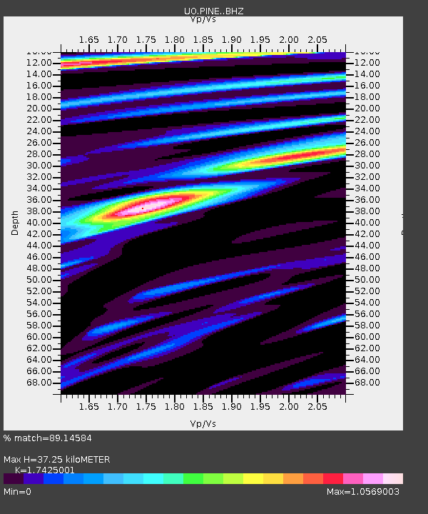
| Estimated Moho Depth: |
37.25 km |
| Estimated Crust Vp/Vs: |
1.74 |
| Assumed Crust Vp: |
6.597 km/s |
| Estimated Crust Vs: |
3.786 km/s |
| Estimated Crust Poisson's Ratio: |
0.25 |
|
| Radial Match: |
89.14584 % |
| Radial Bump: |
400 |
| Transverse Match: |
82.09479 % |
| Transverse Bump: |
400 |
| SOD ConfigId: |
11737051 |
| Insert Time: |
2019-04-27 03:46:25.723 +0000 |
| GWidth: |
2.5 |
| Max Bumps: |
400 |
| Tol: |
0.001 |
|

Signal To Noise
| Channel | StoN | STA | LTA |
| UO:PINE: :BHZ:20170418T17:59:42.564988Z | 14.886641 | 3.8373782E-6 | 2.5777328E-7 |
| UO:PINE: :BHN:20170418T17:59:42.564988Z | 2.1734204 | 6.940528E-7 | 3.1933666E-7 |
| UO:PINE: :BHE:20170418T17:59:42.564988Z | 4.939955 | 1.0758979E-6 | 2.1779508E-7 |
| Arrivals |
| Ps | 4.4 SECOND |
| PpPs | 15 SECOND |
| PsPs/PpSs | 19 SECOND |


