You are here: Home > Network List > TA - USArray Transportable Network (new EarthScope stations) Stations List
> Station X29A Tulia, tX, USA > Earthquake Result Viewer
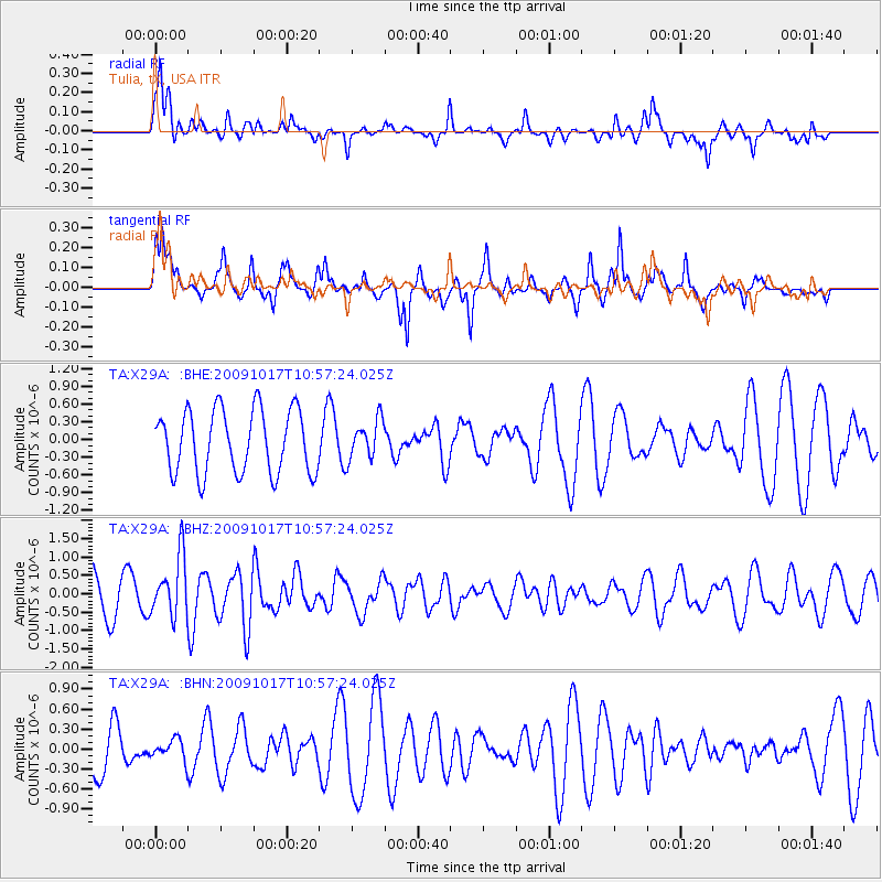
X29A Tulia, tX, USA - Earthquake Result Viewer
*The percent match for this event was below the threshold and hence no stack was calculated.
| Earthquake location: |
Samoa Islands Region |
| Earthquake latitude/longitude: |
-16.4/-172.0 |
| Earthquake time(UTC): |
2009/10/17 (290) 10:45:26 GMT |
| Earthquake Depth: |
10 km |
| Earthquake Magnitude: |
5.7 MB, 5.3 MS, 5.7 MW, 5.7 MW |
| Earthquake Catalog/Contributor: |
WHDF/NEIC |
|
| Network: |
TA USArray Transportable Network (new EarthScope stations) |
| Station: |
X29A Tulia, tX, USA |
| Lat/Lon: |
34.45 N/101.70 W |
| Elevation: |
1039 m |
|
| Distance: |
83.7 deg |
| Az: |
51.512 deg |
| Baz: |
245.401 deg |
| Ray Param: |
$rayparam |
*The percent match for this event was below the threshold and hence was not used in the summary stack. |
|
| Radial Match: |
76.28157 % |
| Radial Bump: |
350 |
| Transverse Match: |
66.224976 % |
| Transverse Bump: |
327 |
| SOD ConfigId: |
2622 |
| Insert Time: |
2010-03-05 23:11:55.100 +0000 |
| GWidth: |
2.5 |
| Max Bumps: |
400 |
| Tol: |
0.001 |
|
Signal To Noise
| Channel | StoN | STA | LTA |
| TA:X29A: :BHZ:20091017T10:57:24.025Z | 1.5937713 | 8.130216E-7 | 5.101244E-7 |
| TA:X29A: :BHN:20091017T10:57:24.025Z | 0.34990272 | 1.4940963E-7 | 4.270033E-7 |
| TA:X29A: :BHE:20091017T10:57:24.025Z | 0.6170077 | 3.290898E-7 | 5.333642E-7 |
| Arrivals |
| Ps | |
| PpPs | |
| PsPs/PpSs | |


