You are here: Home > Network List > YN10 - San Jacinto Fault Zone Stations List
> Station RHIL RHIL > Earthquake Result Viewer
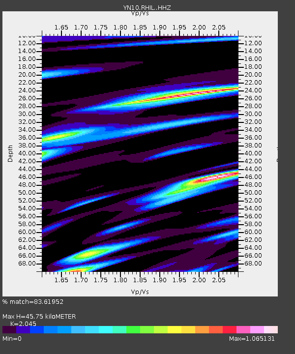
RHIL RHIL - Earthquake Result Viewer
| Earthquake location: |
Peru-Ecuador Border Region |
| Earthquake latitude/longitude: |
-2.7/-75.3 |
| Earthquake time(UTC): |
2017/04/18 (108) 17:49:55 GMT |
| Earthquake Depth: |
11 km |
| Earthquake Magnitude: |
6.0 Mww |
| Earthquake Catalog/Contributor: |
NEIC PDE/us |
|
| Network: |
YN San Jacinto Fault Zone |
| Station: |
RHIL RHIL |
| Lat/Lon: |
33.67 N/116.77 W |
| Elevation: |
1557 m |
|
| Distance: |
53.3 deg |
| Az: |
316.445 deg |
| Baz: |
124.376 deg |
| Ray Param: |
0.066214345 |
| Estimated Moho Depth: |
45.75 km |
| Estimated Crust Vp/Vs: |
2.05 |
| Assumed Crust Vp: |
6.264 km/s |
| Estimated Crust Vs: |
3.063 km/s |
| Estimated Crust Poisson's Ratio: |
0.34 |
|
| Radial Match: |
83.61952 % |
| Radial Bump: |
400 |
| Transverse Match: |
81.94038 % |
| Transverse Bump: |
400 |
| SOD ConfigId: |
11737051 |
| Insert Time: |
2019-04-27 03:48:07.927 +0000 |
| GWidth: |
2.5 |
| Max Bumps: |
400 |
| Tol: |
0.001 |
|

Signal To Noise
| Channel | StoN | STA | LTA |
| YN:RHIL: :HHZ:20170418T17:58:42.824021Z | 9.921062 | 2.7791227E-6 | 2.801235E-7 |
| YN:RHIL: :HHN:20170418T17:58:42.824021Z | 6.2551885 | 1.0973672E-6 | 1.7543312E-7 |
| YN:RHIL: :HHE:20170418T17:58:42.824021Z | 5.399506 | 1.0522494E-6 | 1.9487884E-7 |
| Arrivals |
| Ps | 8.0 SECOND |
| PpPs | 21 SECOND |
| PsPs/PpSs | 29 SECOND |


