You are here: Home > Network List > TA - USArray Transportable Network (new EarthScope stations) Stations List
> Station Z28A Tucker Farm, Meadow, TX, USA > Earthquake Result Viewer
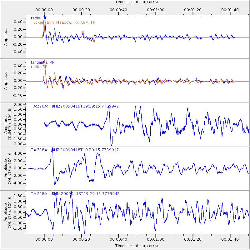
Z28A Tucker Farm, Meadow, TX, USA - Earthquake Result Viewer
| Earthquake location: |
Kuril Islands |
| Earthquake latitude/longitude: |
46.0/151.4 |
| Earthquake time(UTC): |
2009/04/18 (108) 19:17:58 GMT |
| Earthquake Depth: |
35 km |
| Earthquake Magnitude: |
6.3 MB, 6.3 MS, 6.6 MW, 6.4 MW |
| Earthquake Catalog/Contributor: |
WHDF/NEIC |
|
| Network: |
TA USArray Transportable Network (new EarthScope stations) |
| Station: |
Z28A Tucker Farm, Meadow, TX, USA |
| Lat/Lon: |
33.29 N/102.39 W |
| Elevation: |
1045 m |
|
| Distance: |
76.8 deg |
| Az: |
55.728 deg |
| Baz: |
316.564 deg |
| Ray Param: |
0.05072874 |
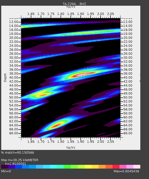
| Estimated Moho Depth: |
38.25 km |
| Estimated Crust Vp/Vs: |
1.91 |
| Assumed Crust Vp: |
6.129 km/s |
| Estimated Crust Vs: |
3.209 km/s |
| Estimated Crust Poisson's Ratio: |
0.31 |
|
| Radial Match: |
90.150566 % |
| Radial Bump: |
400 |
| Transverse Match: |
81.208725 % |
| Transverse Bump: |
400 |
| SOD ConfigId: |
2760 |
| Insert Time: |
2010-03-05 23:12:25.393 +0000 |
| GWidth: |
2.5 |
| Max Bumps: |
400 |
| Tol: |
0.001 |
|
Signal To Noise
| Channel | StoN | STA | LTA |
| TA:Z28A: :BHZ:20090418T19:29:15.773994Z | 25.552034 | 2.3449234E-6 | 9.177052E-8 |
| TA:Z28A: :BHN:20090418T19:29:15.773994Z | 4.076129 | 6.959505E-7 | 1.7073809E-7 |
| TA:Z28A: :BHE:20090418T19:29:15.773994Z | 3.4415061 | 7.0469196E-7 | 2.0476266E-7 |
| Arrivals |
| Ps | 5.8 SECOND |
| PpPs | 18 SECOND |
| PsPs/PpSs | 24 SECOND |


