You are here: Home > Network List > TA - USArray Transportable Network (new EarthScope stations) Stations List
> Station Z28A Tucker Farm, Meadow, TX, USA > Earthquake Result Viewer
Z28A Tucker Farm, Meadow, TX, USA - Earthquake Result Viewer
| Earthquake location: |
Tonga Islands |
| Earthquake latitude/longitude: |
-20.8/-174.3 |
| Earthquake time(UTC): |
2009/07/30 (211) 20:05:34 GMT |
| Earthquake Depth: |
10 km |
| Earthquake Magnitude: |
5.9 MB, 5.7 MS, 5.8 MW, 5.7 MW |
| Earthquake Catalog/Contributor: |
WHDF/NEIC |
|
| Network: |
TA USArray Transportable Network (new EarthScope stations) |
| Station: |
Z28A Tucker Farm, Meadow, TX, USA |
| Lat/Lon: |
33.29 N/102.39 W |
| Elevation: |
1045 m |
|
| Distance: |
87.1 deg |
| Az: |
52.847 deg |
| Baz: |
242.874 deg |
| Ray Param: |
0.043566268 |
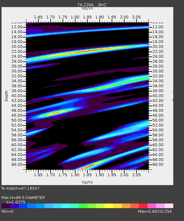
| Estimated Moho Depth: |
69.5 km |
| Estimated Crust Vp/Vs: |
1.83 |
| Assumed Crust Vp: |
6.129 km/s |
| Estimated Crust Vs: |
3.354 km/s |
| Estimated Crust Poisson's Ratio: |
0.29 |
|
| Radial Match: |
87.19047 % |
| Radial Bump: |
400 |
| Transverse Match: |
73.50694 % |
| Transverse Bump: |
400 |
| SOD ConfigId: |
2622 |
| Insert Time: |
2010-03-05 23:12:29.066 +0000 |
| GWidth: |
2.5 |
| Max Bumps: |
400 |
| Tol: |
0.001 |
|

Signal To Noise
| Channel | StoN | STA | LTA |
| TA:Z28A: :BHZ:20090730T20:17:49.325022Z | 6.234231 | 5.0947483E-7 | 8.172216E-8 |
| TA:Z28A: :BHN:20090730T20:17:49.325022Z | 0.94289106 | 1.1965965E-7 | 1.2690717E-7 |
| TA:Z28A: :BHE:20090730T20:17:49.325022Z | 1.7587594 | 1.8844116E-7 | 1.0714437E-7 |
| Arrivals |
| Ps | 9.6 SECOND |
| PpPs | 31 SECOND |
| PsPs/PpSs | 41 SECOND |


