You are here: Home > Network List > IU - Global Seismograph Network (GSN - IRIS/USGS) Stations List
> Station GRFO Grafenberg, Germany > Earthquake Result Viewer
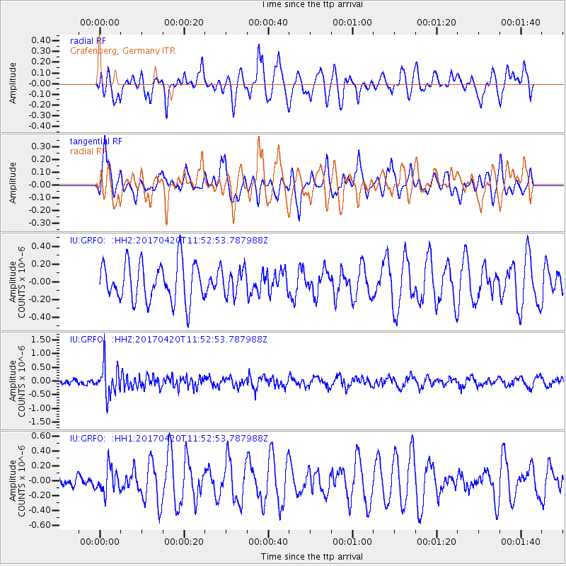
GRFO Grafenberg, Germany - Earthquake Result Viewer
*The percent match for this event was below the threshold and hence no stack was calculated.
| Earthquake location: |
Kuril Islands |
| Earthquake latitude/longitude: |
44.4/148.7 |
| Earthquake time(UTC): |
2017/04/20 (110) 11:41:26 GMT |
| Earthquake Depth: |
61 km |
| Earthquake Magnitude: |
5.5 mb |
| Earthquake Catalog/Contributor: |
NEIC PDE/us |
|
| Network: |
IU Global Seismograph Network (GSN - IRIS/USGS) |
| Station: |
GRFO Grafenberg, Germany |
| Lat/Lon: |
49.69 N/11.22 E |
| Elevation: |
384 m |
|
| Distance: |
79.2 deg |
| Az: |
333.476 deg |
| Baz: |
29.516 deg |
| Ray Param: |
$rayparam |
*The percent match for this event was below the threshold and hence was not used in the summary stack. |
|
| Radial Match: |
49.383728 % |
| Radial Bump: |
400 |
| Transverse Match: |
54.77774 % |
| Transverse Bump: |
400 |
| SOD ConfigId: |
11737051 |
| Insert Time: |
2019-04-27 03:54:00.833 +0000 |
| GWidth: |
2.5 |
| Max Bumps: |
400 |
| Tol: |
0.001 |
|
Signal To Noise
| Channel | StoN | STA | LTA |
| IU:GRFO: :HHZ:20170420T11:52:53.787988Z | 5.5647287 | 5.6351763E-7 | 1.0126596E-7 |
| IU:GRFO: :HH1:20170420T11:52:53.787988Z | 1.106746 | 1.7305365E-7 | 1.5636259E-7 |
| IU:GRFO: :HH2:20170420T11:52:53.787988Z | 0.65791756 | 1.4324924E-7 | 2.177313E-7 |
| Arrivals |
| Ps | |
| PpPs | |
| PsPs/PpSs | |


