You are here: Home > Network List > GS - US Geological Survey Networks Stations List
> Station DEC07 Decatur Surface Seismic Site, Decatur, IL, USA > Earthquake Result Viewer
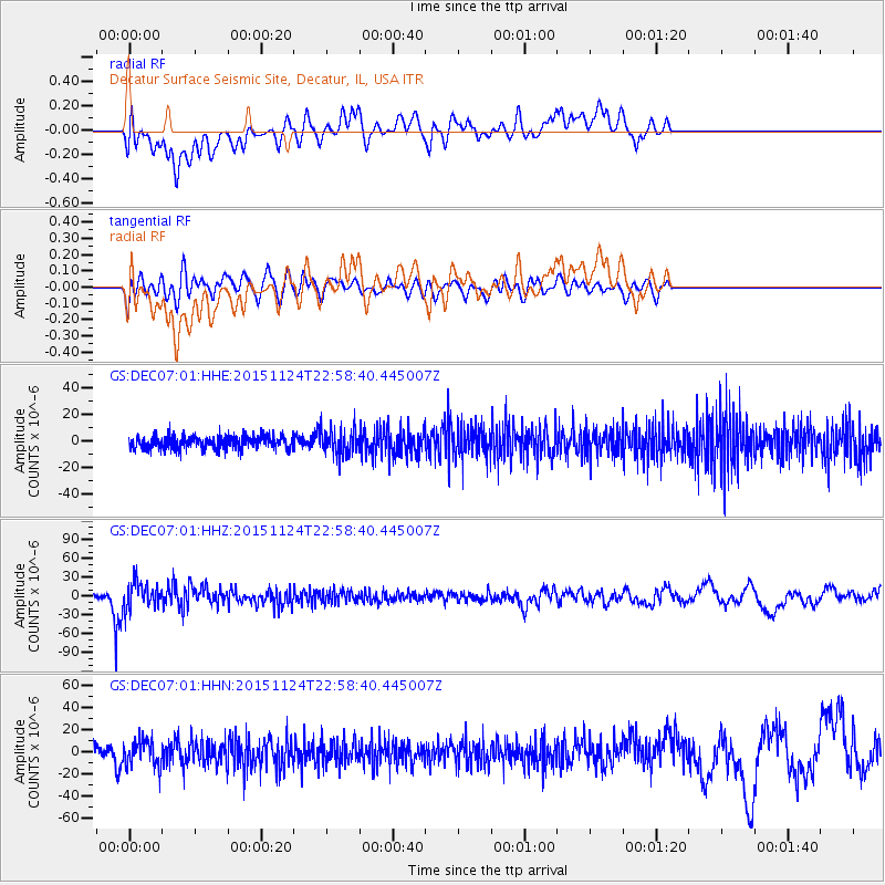
DEC07 Decatur Surface Seismic Site, Decatur, IL, USA - Earthquake Result Viewer
*The percent match for this event was below the threshold and hence no stack was calculated.
| Earthquake location: |
Peru-Brazil Border Region |
| Earthquake latitude/longitude: |
-10.1/-71.1 |
| Earthquake time(UTC): |
2015/11/24 (328) 22:50:53 GMT |
| Earthquake Depth: |
595 km |
| Earthquake Magnitude: |
5.9 MB |
| Earthquake Catalog/Contributor: |
NEIC PDE/NEIC COMCAT |
|
| Network: |
GS US Geological Survey Networks |
| Station: |
DEC07 Decatur Surface Seismic Site, Decatur, IL, USA |
| Lat/Lon: |
39.86 N/88.90 W |
| Elevation: |
212 m |
|
| Distance: |
52.4 deg |
| Az: |
342.7 deg |
| Baz: |
157.638 deg |
| Ray Param: |
$rayparam |
*The percent match for this event was below the threshold and hence was not used in the summary stack. |
|
| Radial Match: |
35.111526 % |
| Radial Bump: |
400 |
| Transverse Match: |
46.414227 % |
| Transverse Bump: |
400 |
| SOD ConfigId: |
1259291 |
| Insert Time: |
2015-12-08 23:55:18.745 +0000 |
| GWidth: |
2.5 |
| Max Bumps: |
400 |
| Tol: |
0.001 |
|
Signal To Noise
| Channel | StoN | STA | LTA |
| GS:DEC07:01:HHZ:20151124T22:58:40.445007Z | 6.5698533 | 2.0953403E-5 | 3.1893258E-6 |
| GS:DEC07:01:HHN:20151124T22:58:40.445007Z | 2.2773685 | 1.131488E-5 | 4.9684013E-6 |
| GS:DEC07:01:HHE:20151124T22:58:40.445007Z | 2.005504 | 9.42949E-6 | 4.7018057E-6 |
| Arrivals |
| Ps | |
| PpPs | |
| PsPs/PpSs | |


