You are here: Home > Network List > MN - MEDNET Project Stations List
> Station VTS Vitosha, Bulgary > Earthquake Result Viewer
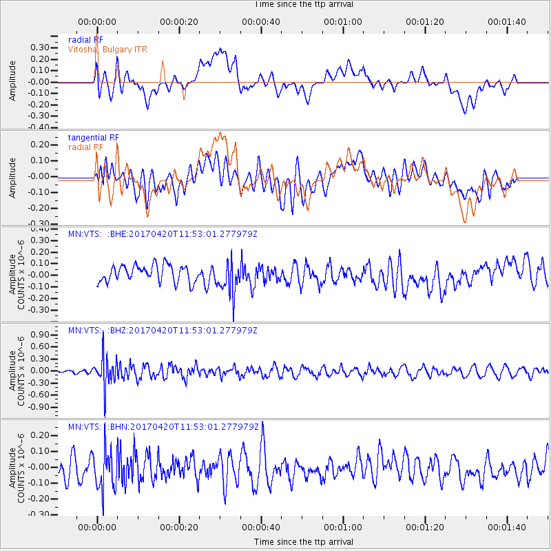
VTS Vitosha, Bulgary - Earthquake Result Viewer
*The percent match for this event was below the threshold and hence no stack was calculated.
| Earthquake location: |
Kuril Islands |
| Earthquake latitude/longitude: |
44.4/148.7 |
| Earthquake time(UTC): |
2017/04/20 (110) 11:41:26 GMT |
| Earthquake Depth: |
61 km |
| Earthquake Magnitude: |
5.5 mb |
| Earthquake Catalog/Contributor: |
NEIC PDE/us |
|
| Network: |
MN MEDNET Project |
| Station: |
VTS Vitosha, Bulgary |
| Lat/Lon: |
42.62 N/23.24 E |
| Elevation: |
1490 m |
|
| Distance: |
80.6 deg |
| Az: |
322.471 deg |
| Baz: |
36.248 deg |
| Ray Param: |
$rayparam |
*The percent match for this event was below the threshold and hence was not used in the summary stack. |
|
| Radial Match: |
31.339869 % |
| Radial Bump: |
400 |
| Transverse Match: |
36.183094 % |
| Transverse Bump: |
400 |
| SOD ConfigId: |
11737051 |
| Insert Time: |
2019-04-27 03:54:41.888 +0000 |
| GWidth: |
2.5 |
| Max Bumps: |
400 |
| Tol: |
0.001 |
|
Signal To Noise
| Channel | StoN | STA | LTA |
| MN:VTS: :BHZ:20170420T11:53:01.277979Z | 7.226912 | 3.6651605E-7 | 5.0715446E-8 |
| MN:VTS: :BHN:20170420T11:53:01.277979Z | 2.3113165 | 1.2694248E-7 | 5.4922157E-8 |
| MN:VTS: :BHE:20170420T11:53:01.277979Z | 2.0071938 | 1.4148067E-7 | 7.0486806E-8 |
| Arrivals |
| Ps | |
| PpPs | |
| PsPs/PpSs | |


