You are here: Home > Network List > TA - USArray Transportable Network (new EarthScope stations) Stations List
> Station Z28A Tucker Farm, Meadow, TX, USA > Earthquake Result Viewer
Z28A Tucker Farm, Meadow, TX, USA - Earthquake Result Viewer
| Earthquake location: |
Near Coast Of Venezuela |
| Earthquake latitude/longitude: |
10.7/-67.9 |
| Earthquake time(UTC): |
2009/09/12 (255) 20:06:24 GMT |
| Earthquake Depth: |
10 km |
| Earthquake Magnitude: |
6.3 MB, 6.4 MS, 6.3 MW, 6.3 MW |
| Earthquake Catalog/Contributor: |
WHDF/NEIC |
|
| Network: |
TA USArray Transportable Network (new EarthScope stations) |
| Station: |
Z28A Tucker Farm, Meadow, TX, USA |
| Lat/Lon: |
33.29 N/102.39 W |
| Elevation: |
1045 m |
|
| Distance: |
38.8 deg |
| Az: |
310.82 deg |
| Baz: |
117.38 deg |
| Ray Param: |
0.075362496 |
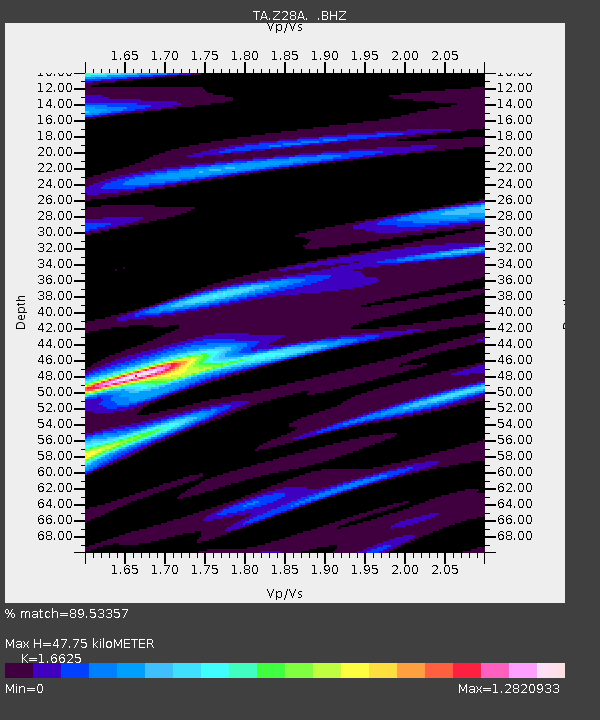
| Estimated Moho Depth: |
47.75 km |
| Estimated Crust Vp/Vs: |
1.66 |
| Assumed Crust Vp: |
6.129 km/s |
| Estimated Crust Vs: |
3.687 km/s |
| Estimated Crust Poisson's Ratio: |
0.22 |
|
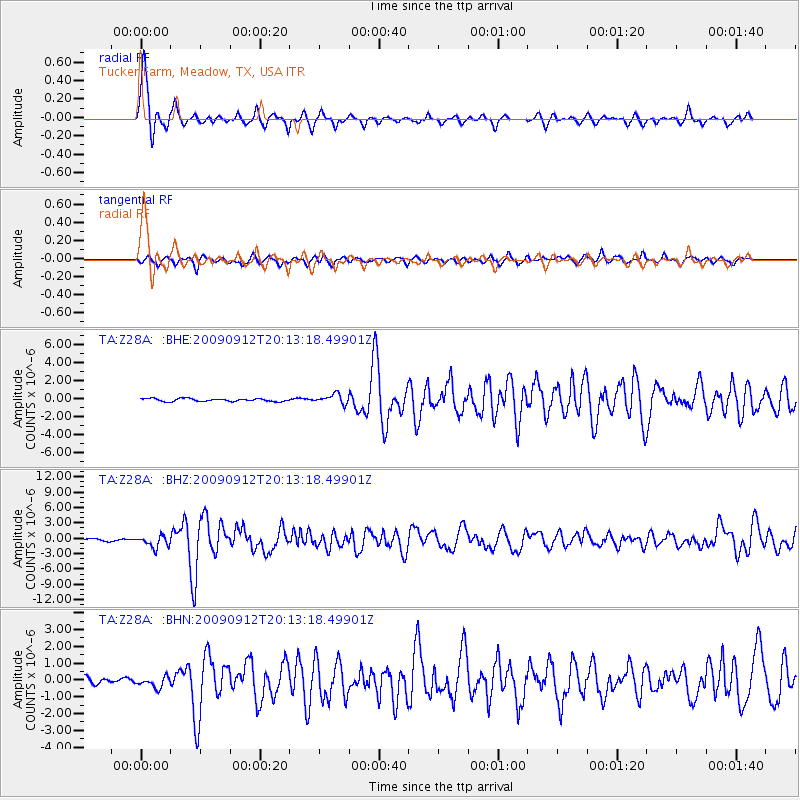
| Radial Match: |
89.53357 % |
| Radial Bump: |
330 |
| Transverse Match: |
79.47923 % |
| Transverse Bump: |
372 |
| SOD ConfigId: |
2622 |
| Insert Time: |
2010-03-05 23:12:38.157 +0000 |
| GWidth: |
2.5 |
| Max Bumps: |
400 |
| Tol: |
0.001 |
|
Signal To Noise
| Channel | StoN | STA | LTA |
| TA:Z28A: :BHZ:20090912T20:13:18.49901Z | 7.6831007 | 1.1469207E-6 | 1.4927835E-7 |
| TA:Z28A: :BHN:20090912T20:13:18.49901Z | 1.7583569 | 3.0813916E-7 | 1.7524266E-7 |
| TA:Z28A: :BHE:20090912T20:13:18.49901Z | 3.4294803 | 5.2925225E-7 | 1.5432433E-7 |
| Arrivals |
| Ps | 5.5 SECOND |
| PpPs | 19 SECOND |
| PsPs/PpSs | 25 SECOND |


