You are here: Home > Network List > TA - USArray Transportable Network (new EarthScope stations) Stations List
> Station D25K Kavik River, AK, USA > Earthquake Result Viewer
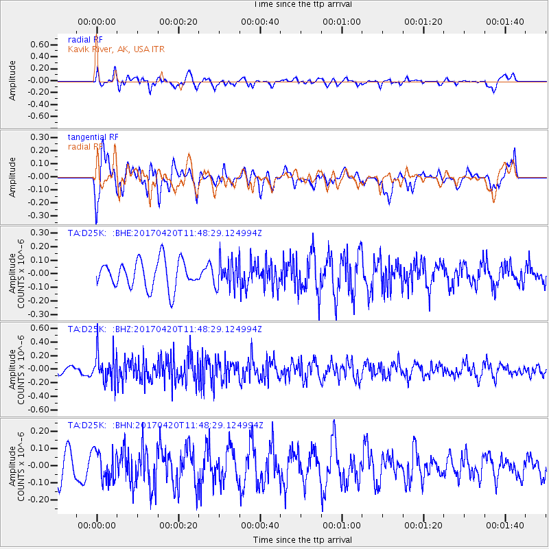
D25K Kavik River, AK, USA - Earthquake Result Viewer
*The percent match for this event was below the threshold and hence no stack was calculated.
| Earthquake location: |
Kuril Islands |
| Earthquake latitude/longitude: |
44.4/148.7 |
| Earthquake time(UTC): |
2017/04/20 (110) 11:41:26 GMT |
| Earthquake Depth: |
61 km |
| Earthquake Magnitude: |
5.5 mb |
| Earthquake Catalog/Contributor: |
NEIC PDE/us |
|
| Network: |
TA USArray Transportable Network (new EarthScope stations) |
| Station: |
D25K Kavik River, AK, USA |
| Lat/Lon: |
69.32 N/146.38 W |
| Elevation: |
770 m |
|
| Distance: |
40.5 deg |
| Az: |
29.668 deg |
| Baz: |
266.79 deg |
| Ray Param: |
$rayparam |
*The percent match for this event was below the threshold and hence was not used in the summary stack. |
|
| Radial Match: |
47.70923 % |
| Radial Bump: |
400 |
| Transverse Match: |
58.42694 % |
| Transverse Bump: |
400 |
| SOD ConfigId: |
11737051 |
| Insert Time: |
2019-04-27 03:57:48.170 +0000 |
| GWidth: |
2.5 |
| Max Bumps: |
400 |
| Tol: |
0.001 |
|
Signal To Noise
| Channel | StoN | STA | LTA |
| TA:D25K: :BHZ:20170420T11:48:29.124994Z | 3.0140705 | 2.2591296E-7 | 7.495277E-8 |
| TA:D25K: :BHN:20170420T11:48:29.124994Z | 1.0829531 | 8.61431E-8 | 7.954463E-8 |
| TA:D25K: :BHE:20170420T11:48:29.124994Z | 0.9681193 | 9.920743E-8 | 1.0247438E-7 |
| Arrivals |
| Ps | |
| PpPs | |
| PsPs/PpSs | |


