You are here: Home > Network List > TA - USArray Transportable Network (new EarthScope stations) Stations List
> Station G22K Bettles, AK, USA > Earthquake Result Viewer
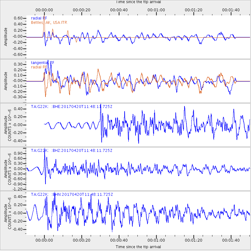
G22K Bettles, AK, USA - Earthquake Result Viewer
*The percent match for this event was below the threshold and hence no stack was calculated.
| Earthquake location: |
Kuril Islands |
| Earthquake latitude/longitude: |
44.4/148.7 |
| Earthquake time(UTC): |
2017/04/20 (110) 11:41:26 GMT |
| Earthquake Depth: |
61 km |
| Earthquake Magnitude: |
5.5 mb |
| Earthquake Catalog/Contributor: |
NEIC PDE/us |
|
| Network: |
TA USArray Transportable Network (new EarthScope stations) |
| Station: |
G22K Bettles, AK, USA |
| Lat/Lon: |
66.92 N/151.51 W |
| Elevation: |
205 m |
|
| Distance: |
38.4 deg |
| Az: |
33.226 deg |
| Baz: |
264.777 deg |
| Ray Param: |
$rayparam |
*The percent match for this event was below the threshold and hence was not used in the summary stack. |
|
| Radial Match: |
52.163433 % |
| Radial Bump: |
400 |
| Transverse Match: |
76.10169 % |
| Transverse Bump: |
400 |
| SOD ConfigId: |
11737051 |
| Insert Time: |
2019-04-27 03:57:57.361 +0000 |
| GWidth: |
2.5 |
| Max Bumps: |
400 |
| Tol: |
0.001 |
|
Signal To Noise
| Channel | StoN | STA | LTA |
| TA:G22K: :BHZ:20170420T11:48:11.725Z | 5.305325 | 4.1143085E-7 | 7.7550546E-8 |
| TA:G22K: :BHN:20170420T11:48:11.725Z | 2.792048 | 2.229071E-7 | 7.983642E-8 |
| TA:G22K: :BHE:20170420T11:48:11.725Z | 3.9329216 | 2.1387923E-7 | 5.4381772E-8 |
| Arrivals |
| Ps | |
| PpPs | |
| PsPs/PpSs | |


