You are here: Home > Network List > TA - USArray Transportable Network (new EarthScope stations) Stations List
> Station I23K Minto, Yukon-Koyukuk, AK, USA > Earthquake Result Viewer
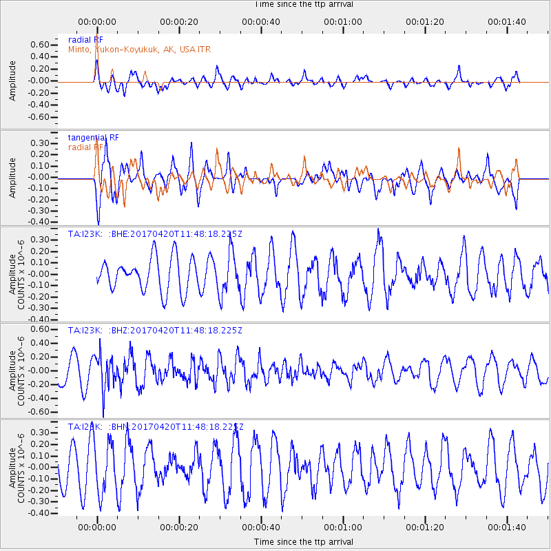
I23K Minto, Yukon-Koyukuk, AK, USA - Earthquake Result Viewer
*The percent match for this event was below the threshold and hence no stack was calculated.
| Earthquake location: |
Kuril Islands |
| Earthquake latitude/longitude: |
44.4/148.7 |
| Earthquake time(UTC): |
2017/04/20 (110) 11:41:26 GMT |
| Earthquake Depth: |
61 km |
| Earthquake Magnitude: |
5.5 mb |
| Earthquake Catalog/Contributor: |
NEIC PDE/us |
|
| Network: |
TA USArray Transportable Network (new EarthScope stations) |
| Station: |
I23K Minto, Yukon-Koyukuk, AK, USA |
| Lat/Lon: |
65.15 N/149.36 W |
| Elevation: |
149 m |
|
| Distance: |
39.2 deg |
| Az: |
36.139 deg |
| Baz: |
269.007 deg |
| Ray Param: |
$rayparam |
*The percent match for this event was below the threshold and hence was not used in the summary stack. |
|
| Radial Match: |
52.743492 % |
| Radial Bump: |
400 |
| Transverse Match: |
71.82141 % |
| Transverse Bump: |
400 |
| SOD ConfigId: |
11737051 |
| Insert Time: |
2019-04-27 03:58:05.206 +0000 |
| GWidth: |
2.5 |
| Max Bumps: |
400 |
| Tol: |
0.001 |
|
Signal To Noise
| Channel | StoN | STA | LTA |
| TA:I23K: :BHZ:20170420T11:48:18.225Z | 2.0049558 | 2.436999E-7 | 1.2154877E-7 |
| TA:I23K: :BHN:20170420T11:48:18.225Z | 1.0155066 | 2.2007075E-7 | 2.167103E-7 |
| TA:I23K: :BHE:20170420T11:48:18.225Z | 1.2727805 | 1.8233483E-7 | 1.4325708E-7 |
| Arrivals |
| Ps | |
| PpPs | |
| PsPs/PpSs | |


