You are here: Home > Network List > TA - USArray Transportable Network (new EarthScope stations) Stations List
> Station K29M Barlow Dome, YT, CAN > Earthquake Result Viewer
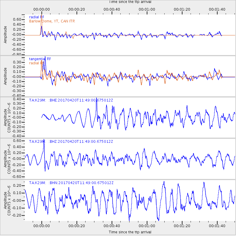
K29M Barlow Dome, YT, CAN - Earthquake Result Viewer
*The percent match for this event was below the threshold and hence no stack was calculated.
| Earthquake location: |
Kuril Islands |
| Earthquake latitude/longitude: |
44.4/148.7 |
| Earthquake time(UTC): |
2017/04/20 (110) 11:41:26 GMT |
| Earthquake Depth: |
61 km |
| Earthquake Magnitude: |
5.5 mb |
| Earthquake Catalog/Contributor: |
NEIC PDE/us |
|
| Network: |
TA USArray Transportable Network (new EarthScope stations) |
| Station: |
K29M Barlow Dome, YT, CAN |
| Lat/Lon: |
63.84 N/137.52 W |
| Elevation: |
1367 m |
|
| Distance: |
44.4 deg |
| Az: |
37.44 deg |
| Baz: |
280.659 deg |
| Ray Param: |
$rayparam |
*The percent match for this event was below the threshold and hence was not used in the summary stack. |
|
| Radial Match: |
43.683315 % |
| Radial Bump: |
400 |
| Transverse Match: |
58.522015 % |
| Transverse Bump: |
400 |
| SOD ConfigId: |
11737051 |
| Insert Time: |
2019-04-27 03:58:08.543 +0000 |
| GWidth: |
2.5 |
| Max Bumps: |
400 |
| Tol: |
0.001 |
|
Signal To Noise
| Channel | StoN | STA | LTA |
| TA:K29M: :BHZ:20170420T11:49:00.675012Z | 2.468843 | 2.5664863E-7 | 1.03955024E-7 |
| TA:K29M: :BHN:20170420T11:49:00.675012Z | 0.94811994 | 8.3108084E-8 | 8.7655664E-8 |
| TA:K29M: :BHE:20170420T11:49:00.675012Z | 2.1572087 | 1.600336E-7 | 7.41855E-8 |
| Arrivals |
| Ps | |
| PpPs | |
| PsPs/PpSs | |


