You are here: Home > Network List > TA - USArray Transportable Network (new EarthScope stations) Stations List
> Station M31M Drury Creek, Yukon, CA > Earthquake Result Viewer
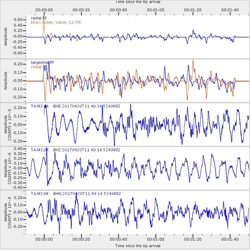
M31M Drury Creek, Yukon, CA - Earthquake Result Viewer
*The percent match for this event was below the threshold and hence no stack was calculated.
| Earthquake location: |
Kuril Islands |
| Earthquake latitude/longitude: |
44.4/148.7 |
| Earthquake time(UTC): |
2017/04/20 (110) 11:41:26 GMT |
| Earthquake Depth: |
61 km |
| Earthquake Magnitude: |
5.5 mb |
| Earthquake Catalog/Contributor: |
NEIC PDE/us |
|
| Network: |
TA USArray Transportable Network (new EarthScope stations) |
| Station: |
M31M Drury Creek, Yukon, CA |
| Lat/Lon: |
62.20 N/134.39 W |
| Elevation: |
639 m |
|
| Distance: |
46.2 deg |
| Az: |
39.259 deg |
| Baz: |
284.724 deg |
| Ray Param: |
$rayparam |
*The percent match for this event was below the threshold and hence was not used in the summary stack. |
|
| Radial Match: |
54.588097 % |
| Radial Bump: |
400 |
| Transverse Match: |
55.249172 % |
| Transverse Bump: |
400 |
| SOD ConfigId: |
11737051 |
| Insert Time: |
2019-04-27 03:58:12.859 +0000 |
| GWidth: |
2.5 |
| Max Bumps: |
400 |
| Tol: |
0.001 |
|
Signal To Noise
| Channel | StoN | STA | LTA |
| TA:M31M: :BHZ:20170420T11:49:14.524988Z | 3.122343 | 2.1776921E-7 | 6.974545E-8 |
| TA:M31M: :BHN:20170420T11:49:14.524988Z | 1.693681 | 1.0392364E-7 | 6.135963E-8 |
| TA:M31M: :BHE:20170420T11:49:14.524988Z | 0.7413697 | 7.837807E-8 | 1.0572062E-7 |
| Arrivals |
| Ps | |
| PpPs | |
| PsPs/PpSs | |


