You are here: Home > Network List > TA - USArray Transportable Network (new EarthScope stations) Stations List
> Station MDND Maddock, ND, USA > Earthquake Result Viewer
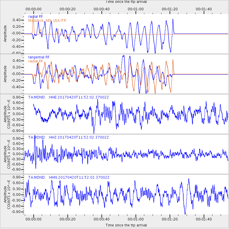
MDND Maddock, ND, USA - Earthquake Result Viewer
*The percent match for this event was below the threshold and hence no stack was calculated.
| Earthquake location: |
Kuril Islands |
| Earthquake latitude/longitude: |
44.4/148.7 |
| Earthquake time(UTC): |
2017/04/20 (110) 11:41:26 GMT |
| Earthquake Depth: |
61 km |
| Earthquake Magnitude: |
5.5 mb |
| Earthquake Catalog/Contributor: |
NEIC PDE/us |
|
| Network: |
TA USArray Transportable Network (new EarthScope stations) |
| Station: |
MDND Maddock, ND, USA |
| Lat/Lon: |
47.85 N/99.60 W |
| Elevation: |
479 m |
|
| Distance: |
70.3 deg |
| Az: |
41.682 deg |
| Baz: |
314.98 deg |
| Ray Param: |
$rayparam |
*The percent match for this event was below the threshold and hence was not used in the summary stack. |
|
| Radial Match: |
51.034122 % |
| Radial Bump: |
395 |
| Transverse Match: |
60.34143 % |
| Transverse Bump: |
394 |
| SOD ConfigId: |
11737051 |
| Insert Time: |
2019-04-27 03:58:14.219 +0000 |
| GWidth: |
2.5 |
| Max Bumps: |
400 |
| Tol: |
0.001 |
|
Signal To Noise
| Channel | StoN | STA | LTA |
| TA:MDND: :HHZ:20170420T11:52:02.37002Z | 3.036493 | 3.930949E-7 | 1.2945686E-7 |
| TA:MDND: :HHN:20170420T11:52:02.37002Z | 0.8233083 | 2.0141704E-7 | 2.4464353E-7 |
| TA:MDND: :HHE:20170420T11:52:02.37002Z | 1.165686 | 2.4433717E-7 | 2.0960805E-7 |
| Arrivals |
| Ps | |
| PpPs | |
| PsPs/PpSs | |


