You are here: Home > Network List > TA - USArray Transportable Network (new EarthScope stations) Stations List
> Station R17K Ugashik Creek, AK, USA > Earthquake Result Viewer
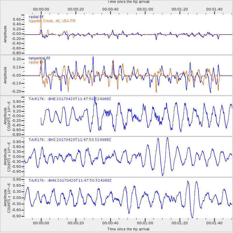
R17K Ugashik Creek, AK, USA - Earthquake Result Viewer
*The percent match for this event was below the threshold and hence no stack was calculated.
| Earthquake location: |
Kuril Islands |
| Earthquake latitude/longitude: |
44.4/148.7 |
| Earthquake time(UTC): |
2017/04/20 (110) 11:41:26 GMT |
| Earthquake Depth: |
61 km |
| Earthquake Magnitude: |
5.5 mb |
| Earthquake Catalog/Contributor: |
NEIC PDE/us |
|
| Network: |
TA USArray Transportable Network (new EarthScope stations) |
| Station: |
R17K Ugashik Creek, AK, USA |
| Lat/Lon: |
57.64 N/156.39 W |
| Elevation: |
273 m |
|
| Distance: |
35.9 deg |
| Az: |
48.572 deg |
| Baz: |
272.706 deg |
| Ray Param: |
$rayparam |
*The percent match for this event was below the threshold and hence was not used in the summary stack. |
|
| Radial Match: |
49.364983 % |
| Radial Bump: |
400 |
| Transverse Match: |
55.16062 % |
| Transverse Bump: |
400 |
| SOD ConfigId: |
11737051 |
| Insert Time: |
2019-04-27 03:58:25.588 +0000 |
| GWidth: |
2.5 |
| Max Bumps: |
400 |
| Tol: |
0.001 |
|
Signal To Noise
| Channel | StoN | STA | LTA |
| TA:R17K: :BHZ:20170420T11:47:50.524988Z | 0.8369283 | 3.011043E-7 | 3.597731E-7 |
| TA:R17K: :BHN:20170420T11:47:50.524988Z | 0.48378444 | 1.6928071E-7 | 3.4990936E-7 |
| TA:R17K: :BHE:20170420T11:47:50.524988Z | 2.0069728 | 4.6176552E-7 | 2.3008063E-7 |
| Arrivals |
| Ps | |
| PpPs | |
| PsPs/PpSs | |


