You are here: Home > Network List > TJ - Tajikistan National Seismic Network Stations List
> Station SHAA Shaartuz, Tajikistan > Earthquake Result Viewer
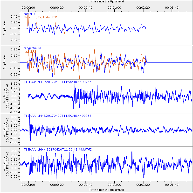
SHAA Shaartuz, Tajikistan - Earthquake Result Viewer
*The percent match for this event was below the threshold and hence no stack was calculated.
| Earthquake location: |
Kuril Islands |
| Earthquake latitude/longitude: |
44.4/148.7 |
| Earthquake time(UTC): |
2017/04/20 (110) 11:41:26 GMT |
| Earthquake Depth: |
61 km |
| Earthquake Magnitude: |
5.5 mb |
| Earthquake Catalog/Contributor: |
NEIC PDE/us |
|
| Network: |
TJ Tajikistan National Seismic Network |
| Station: |
SHAA Shaartuz, Tajikistan |
| Lat/Lon: |
37.56 N/68.12 E |
| Elevation: |
868 m |
|
| Distance: |
58.9 deg |
| Az: |
293.719 deg |
| Baz: |
55.634 deg |
| Ray Param: |
$rayparam |
*The percent match for this event was below the threshold and hence was not used in the summary stack. |
|
| Radial Match: |
66.971504 % |
| Radial Bump: |
400 |
| Transverse Match: |
53.341213 % |
| Transverse Bump: |
400 |
| SOD ConfigId: |
11737051 |
| Insert Time: |
2019-04-27 03:58:37.952 +0000 |
| GWidth: |
2.5 |
| Max Bumps: |
400 |
| Tol: |
0.001 |
|
Signal To Noise
| Channel | StoN | STA | LTA |
| TJ:SHAA: :HHZ:20170420T11:50:48.449976Z | 6.462068 | 1.1813747E-6 | 1.8281682E-7 |
| TJ:SHAA: :HHN:20170420T11:50:48.449976Z | 1.8389325 | 3.257737E-7 | 1.7715371E-7 |
| TJ:SHAA: :HHE:20170420T11:50:48.449976Z | 3.051694 | 5.980326E-7 | 1.9596743E-7 |
| Arrivals |
| Ps | |
| PpPs | |
| PsPs/PpSs | |


