You are here: Home > Network List > TA - USArray Transportable Network (new EarthScope stations) Stations List
> Station Z28A Tucker Farm, Meadow, TX, USA > Earthquake Result Viewer
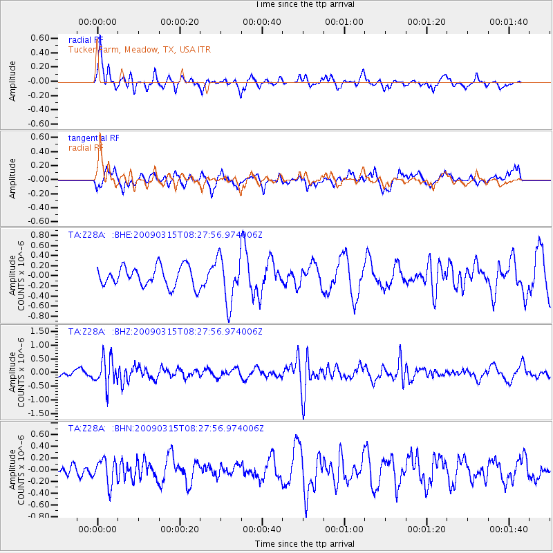
Z28A Tucker Farm, Meadow, TX, USA - Earthquake Result Viewer
*The percent match for this event was below the threshold and hence no stack was calculated.
| Earthquake location: |
Central Peru |
| Earthquake latitude/longitude: |
-14.5/-70.4 |
| Earthquake time(UTC): |
2009/03/15 (074) 08:19:05 GMT |
| Earthquake Depth: |
190 km |
| Earthquake Magnitude: |
5.7 MW, 5.1 MB, 5.6 MW |
| Earthquake Catalog/Contributor: |
WHDF/NEIC |
|
| Network: |
TA USArray Transportable Network (new EarthScope stations) |
| Station: |
Z28A Tucker Farm, Meadow, TX, USA |
| Lat/Lon: |
33.29 N/102.39 W |
| Elevation: |
1045 m |
|
| Distance: |
56.5 deg |
| Az: |
327.802 deg |
| Baz: |
141.955 deg |
| Ray Param: |
$rayparam |
*The percent match for this event was below the threshold and hence was not used in the summary stack. |
|
| Radial Match: |
61.718567 % |
| Radial Bump: |
309 |
| Transverse Match: |
41.34564 % |
| Transverse Bump: |
396 |
| SOD ConfigId: |
2658 |
| Insert Time: |
2010-03-05 23:13:30.031 +0000 |
| GWidth: |
2.5 |
| Max Bumps: |
400 |
| Tol: |
0.001 |
|
Signal To Noise
| Channel | StoN | STA | LTA |
| TA:Z28A: :BHZ:20090315T08:27:56.974006Z | 2.74337 | 5.037148E-7 | 1.8361168E-7 |
| TA:Z28A: :BHN:20090315T08:27:56.974006Z | 0.8171183 | 2.1749479E-7 | 2.6617295E-7 |
| TA:Z28A: :BHE:20090315T08:27:56.974006Z | 2.4025292 | 4.7001933E-7 | 1.9563522E-7 |
| Arrivals |
| Ps | |
| PpPs | |
| PsPs/PpSs | |


