You are here: Home > Network List > TA - USArray Transportable Network (new EarthScope stations) Stations List
> Station MDND Maddock, ND, USA > Earthquake Result Viewer
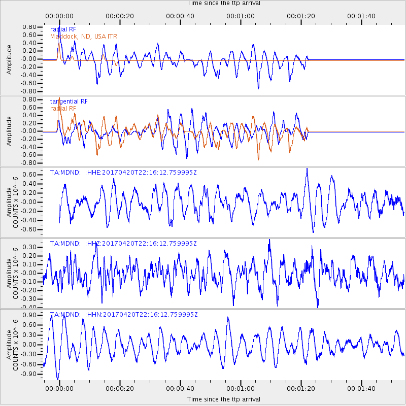
MDND Maddock, ND, USA - Earthquake Result Viewer
*The percent match for this event was below the threshold and hence no stack was calculated.
| Earthquake location: |
Southeast Of Easter Island |
| Earthquake latitude/longitude: |
-36.3/-98.4 |
| Earthquake time(UTC): |
2017/04/20 (110) 22:04:14 GMT |
| Earthquake Depth: |
10 km |
| Earthquake Magnitude: |
5.5 Mwb |
| Earthquake Catalog/Contributor: |
NEIC PDE/us |
|
| Network: |
TA USArray Transportable Network (new EarthScope stations) |
| Station: |
MDND Maddock, ND, USA |
| Lat/Lon: |
47.85 N/99.60 W |
| Elevation: |
479 m |
|
| Distance: |
83.8 deg |
| Az: |
359.187 deg |
| Baz: |
179.026 deg |
| Ray Param: |
$rayparam |
*The percent match for this event was below the threshold and hence was not used in the summary stack. |
|
| Radial Match: |
44.201492 % |
| Radial Bump: |
363 |
| Transverse Match: |
63.319168 % |
| Transverse Bump: |
328 |
| SOD ConfigId: |
11737051 |
| Insert Time: |
2019-04-27 04:06:53.740 +0000 |
| GWidth: |
2.5 |
| Max Bumps: |
400 |
| Tol: |
0.001 |
|
Signal To Noise
| Channel | StoN | STA | LTA |
| TA:MDND: :HHZ:20170420T22:16:12.759995Z | 0.9496494 | 1.16973176E-7 | 1.2317511E-7 |
| TA:MDND: :HHN:20170420T22:16:12.759995Z | 2.1800365 | 5.8896995E-7 | 2.7016517E-7 |
| TA:MDND: :HHE:20170420T22:16:12.759995Z | 1.034885 | 2.439841E-7 | 2.3575963E-7 |
| Arrivals |
| Ps | |
| PpPs | |
| PsPs/PpSs | |


