You are here: Home > Network List > TA - USArray Transportable Network (new EarthScope stations) Stations List
> Station Y29A Porterfield Farm, Petersburg, TX, USA > Earthquake Result Viewer
Y29A Porterfield Farm, Petersburg, TX, USA - Earthquake Result Viewer

| Earthquake location: |
Near S. Coast Of Honshu, Japan |
| Earthquake latitude/longitude: |
33.2/137.9 |
| Earthquake time(UTC): |
2009/08/09 (221) 10:55:55 GMT |
| Earthquake Depth: |
297 km |
| Earthquake Magnitude: |
6.5 MB, 7.1 MW, 7.1 MW |
| Earthquake Catalog/Contributor: |
WHDF/NEIC |
|
| Network: |
TA USArray Transportable Network (new EarthScope stations) |
| Station: |
Y29A Porterfield Farm, Petersburg, TX, USA |
| Lat/Lon: |
33.86 N/101.67 W |
| Elevation: |
991 m |
|
| Distance: |
92.9 deg |
| Az: |
45.951 deg |
| Baz: |
313.575 deg |
| Ray Param: |
0.041170783 |
| Estimated Moho Depth: |
48.0 km |
| Estimated Crust Vp/Vs: |
1.80 |
| Assumed Crust Vp: |
6.426 km/s |
| Estimated Crust Vs: |
3.565 km/s |
| Estimated Crust Poisson's Ratio: |
0.28 |
|
| Radial Match: |
92.676674 % |
| Radial Bump: |
400 |
| Transverse Match: |
81.6105 % |
| Transverse Bump: |
400 |
| SOD ConfigId: |
2622 |
| Insert Time: |
2010-03-05 23:13:47.436 +0000 |
| GWidth: |
2.5 |
| Max Bumps: |
400 |
| Tol: |
0.001 |
|
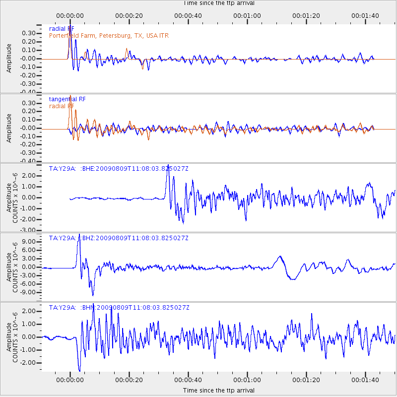
Signal To Noise
| Channel | StoN | STA | LTA |
| TA:Y29A: :BHZ:20090809T11:08:03.825027Z | 51.71102 | 4.401414E-6 | 8.511559E-8 |
| TA:Y29A: :BHN:20090809T11:08:03.825027Z | 12.9097595 | 1.0406278E-6 | 8.060784E-8 |
| TA:Y29A: :BHE:20090809T11:08:03.825027Z | 20.230463 | 1.1947247E-6 | 5.905573E-8 |
| Arrivals |
| Ps | 6.1 SECOND |
| PpPs | 21 SECOND |
| PsPs/PpSs | 27 SECOND |


