You are here: Home > Network List > TA - USArray Transportable Network (new EarthScope stations) Stations List
> Station Y29A Porterfield Farm, Petersburg, TX, USA > Earthquake Result Viewer
Y29A Porterfield Farm, Petersburg, TX, USA - Earthquake Result Viewer
| Earthquake location: |
Samoa Islands Region |
| Earthquake latitude/longitude: |
-15.2/-172.6 |
| Earthquake time(UTC): |
2009/08/30 (242) 14:51:32 GMT |
| Earthquake Depth: |
11 km |
| Earthquake Magnitude: |
6.4 MB, 6.3 MS, 6.6 MW, 6.6 MW |
| Earthquake Catalog/Contributor: |
WHDF/NEIC |
|
| Network: |
TA USArray Transportable Network (new EarthScope stations) |
| Station: |
Y29A Porterfield Farm, Petersburg, TX, USA |
| Lat/Lon: |
33.86 N/101.67 W |
| Elevation: |
991 m |
|
| Distance: |
83.2 deg |
| Az: |
52.36 deg |
| Baz: |
246.729 deg |
| Ray Param: |
0.046345476 |
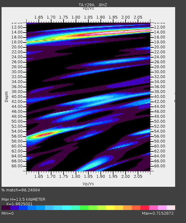
| Estimated Moho Depth: |
13.5 km |
| Estimated Crust Vp/Vs: |
1.99 |
| Assumed Crust Vp: |
6.426 km/s |
| Estimated Crust Vs: |
3.225 km/s |
| Estimated Crust Poisson's Ratio: |
0.33 |
|
| Radial Match: |
96.24884 % |
| Radial Bump: |
368 |
| Transverse Match: |
90.41194 % |
| Transverse Bump: |
400 |
| SOD ConfigId: |
2622 |
| Insert Time: |
2010-03-05 23:13:53.483 +0000 |
| GWidth: |
2.5 |
| Max Bumps: |
400 |
| Tol: |
0.001 |
|

Signal To Noise
| Channel | StoN | STA | LTA |
| TA:Y29A: :BHZ:20090830T15:03:27.673997Z | 25.909794 | 4.765265E-6 | 1.8391752E-7 |
| TA:Y29A: :BHN:20090830T15:03:27.673997Z | 6.6873603 | 7.3855745E-7 | 1.104408E-7 |
| TA:Y29A: :BHE:20090830T15:03:27.673997Z | 9.982716 | 1.4031601E-6 | 1.4055897E-7 |
| Arrivals |
| Ps | 2.1 SECOND |
| PpPs | 6.1 SECOND |
| PsPs/PpSs | 8.3 SECOND |


