You are here: Home > Network List > TA - USArray Transportable Network (new EarthScope stations) Stations List
> Station R17K Ugashik Creek, AK, USA > Earthquake Result Viewer
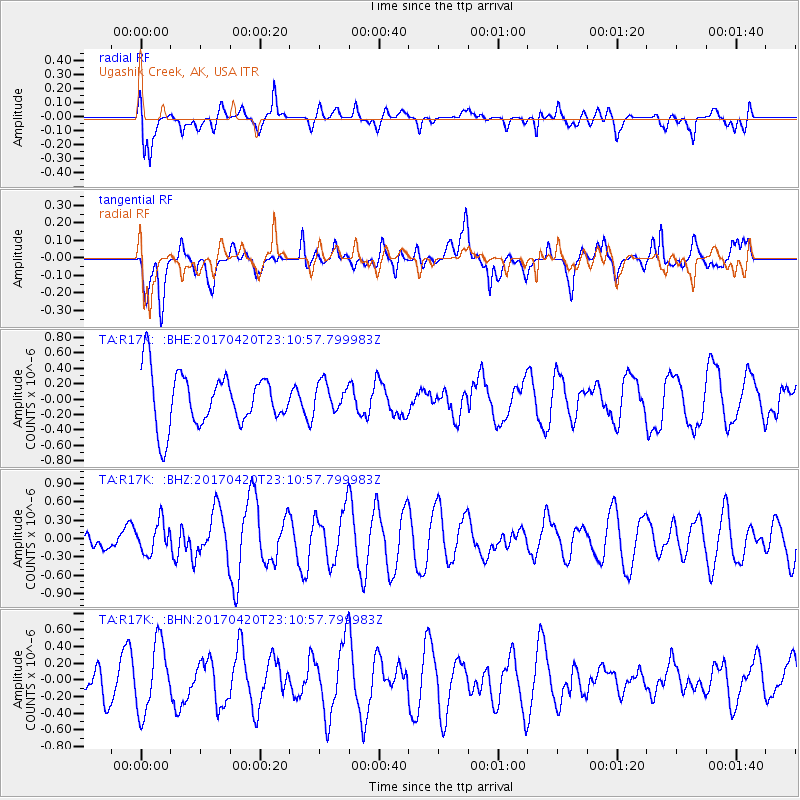
R17K Ugashik Creek, AK, USA - Earthquake Result Viewer
*The percent match for this event was below the threshold and hence no stack was calculated.
| Earthquake location: |
Tonga Islands |
| Earthquake latitude/longitude: |
-20.5/-173.6 |
| Earthquake time(UTC): |
2017/04/20 (110) 22:59:24 GMT |
| Earthquake Depth: |
13 km |
| Earthquake Magnitude: |
5.6 Mww |
| Earthquake Catalog/Contributor: |
NEIC PDE/us |
|
| Network: |
TA USArray Transportable Network (new EarthScope stations) |
| Station: |
R17K Ugashik Creek, AK, USA |
| Lat/Lon: |
57.64 N/156.39 W |
| Elevation: |
273 m |
|
| Distance: |
79.2 deg |
| Az: |
9.325 deg |
| Baz: |
196.401 deg |
| Ray Param: |
$rayparam |
*The percent match for this event was below the threshold and hence was not used in the summary stack. |
|
| Radial Match: |
61.303017 % |
| Radial Bump: |
400 |
| Transverse Match: |
52.398434 % |
| Transverse Bump: |
400 |
| SOD ConfigId: |
11737051 |
| Insert Time: |
2019-04-27 04:15:16.565 +0000 |
| GWidth: |
2.5 |
| Max Bumps: |
400 |
| Tol: |
0.001 |
|
Signal To Noise
| Channel | StoN | STA | LTA |
| TA:R17K: :BHZ:20170420T23:10:57.799983Z | 1.2623463 | 2.4681296E-7 | 1.9551922E-7 |
| TA:R17K: :BHN:20170420T23:10:57.799983Z | 2.399586 | 4.1400966E-7 | 1.725338E-7 |
| TA:R17K: :BHE:20170420T23:10:57.799983Z | 0.53039044 | 1.8320243E-7 | 3.454105E-7 |
| Arrivals |
| Ps | |
| PpPs | |
| PsPs/PpSs | |


