You are here: Home > Network List > IW - Intermountain West Stations List
> Station MOOW Moose Ponds, Wyoming, USA > Earthquake Result Viewer
MOOW Moose Ponds, Wyoming, USA - Earthquake Result Viewer
| Earthquake location: |
Peru-Brazil Border Region |
| Earthquake latitude/longitude: |
-10.1/-71.1 |
| Earthquake time(UTC): |
2015/11/24 (328) 22:50:53 GMT |
| Earthquake Depth: |
595 km |
| Earthquake Magnitude: |
5.9 MB |
| Earthquake Catalog/Contributor: |
NEIC PDE/NEIC COMCAT |
|
| Network: |
IW Intermountain West |
| Station: |
MOOW Moose Ponds, Wyoming, USA |
| Lat/Lon: |
43.75 N/110.74 W |
| Elevation: |
2128 m |
|
| Distance: |
64.6 deg |
| Az: |
329.19 deg |
| Baz: |
135.897 deg |
| Ray Param: |
0.056593973 |
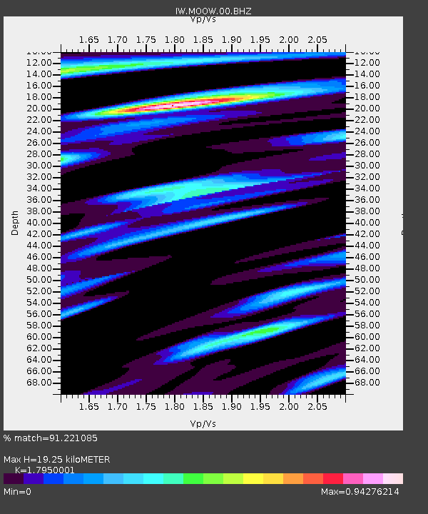
| Estimated Moho Depth: |
19.25 km |
| Estimated Crust Vp/Vs: |
1.80 |
| Assumed Crust Vp: |
6.207 km/s |
| Estimated Crust Vs: |
3.458 km/s |
| Estimated Crust Poisson's Ratio: |
0.27 |
|
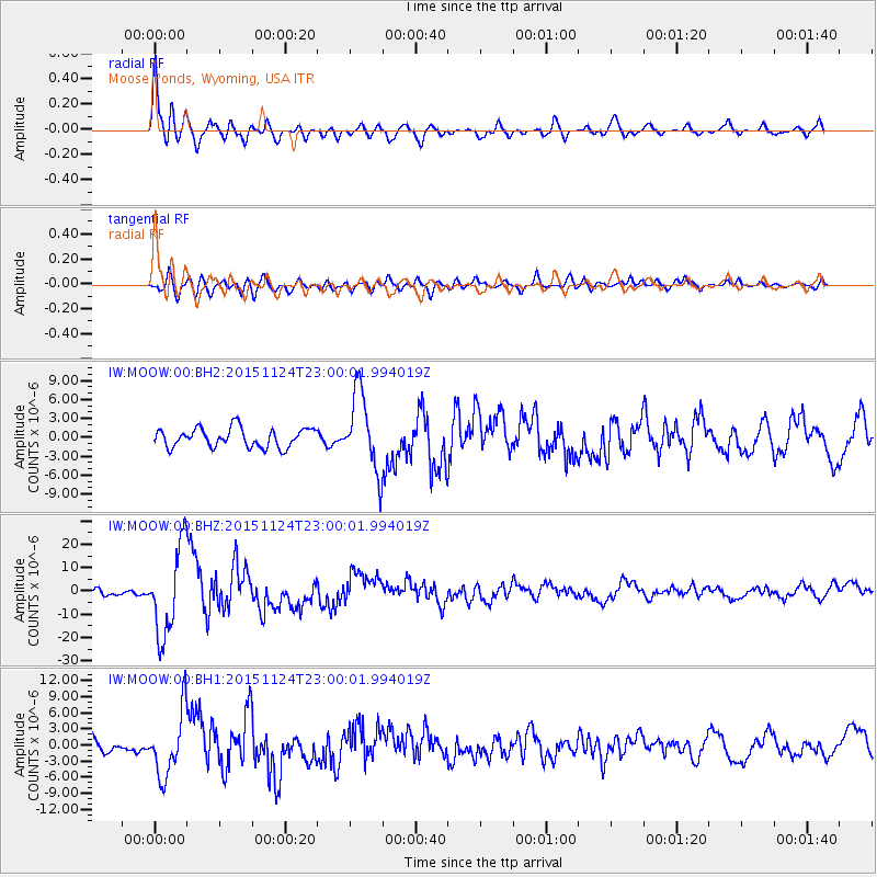
| Radial Match: |
91.221085 % |
| Radial Bump: |
400 |
| Transverse Match: |
72.45303 % |
| Transverse Bump: |
400 |
| SOD ConfigId: |
1259291 |
| Insert Time: |
2015-12-08 23:59:31.558 +0000 |
| GWidth: |
2.5 |
| Max Bumps: |
400 |
| Tol: |
0.001 |
|
Signal To Noise
| Channel | StoN | STA | LTA |
| IW:MOOW:00:BHZ:20151124T23:00:01.994019Z | 11.241434 | 1.871163E-5 | 1.6645233E-6 |
| IW:MOOW:00:BH1:20151124T23:00:01.994019Z | 4.277898 | 5.9549293E-6 | 1.3920222E-6 |
| IW:MOOW:00:BH2:20151124T23:00:01.994019Z | 4.11099 | 6.1447545E-6 | 1.494714E-6 |
| Arrivals |
| Ps | 2.6 SECOND |
| PpPs | 8.4 SECOND |
| PsPs/PpSs | 11 SECOND |


