You are here: Home > Network List > TA - USArray Transportable Network (new EarthScope stations) Stations List
> Station 129A Stewart Farms, Lamesa, TX, USA > Earthquake Result Viewer
129A Stewart Farms, Lamesa, TX, USA - Earthquake Result Viewer
| Earthquake location: |
Easter Island Region |
| Earthquake latitude/longitude: |
-29.1/-112.3 |
| Earthquake time(UTC): |
2009/09/17 (260) 23:21:38 GMT |
| Earthquake Depth: |
10 km |
| Earthquake Magnitude: |
5.7 MB, 6.0 MS, 6.2 MW, 6.2 MW |
| Earthquake Catalog/Contributor: |
WHDF/NEIC |
|
| Network: |
TA USArray Transportable Network (new EarthScope stations) |
| Station: |
129A Stewart Farms, Lamesa, TX, USA |
| Lat/Lon: |
32.63 N/101.87 W |
| Elevation: |
876 m |
|
| Distance: |
62.2 deg |
| Az: |
9.914 deg |
| Baz: |
190.282 deg |
| Ray Param: |
0.060367092 |
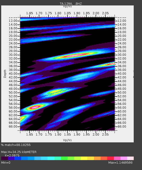
| Estimated Moho Depth: |
34.25 km |
| Estimated Crust Vp/Vs: |
2.10 |
| Assumed Crust Vp: |
6.426 km/s |
| Estimated Crust Vs: |
3.064 km/s |
| Estimated Crust Poisson's Ratio: |
0.35 |
|
| Radial Match: |
88.18255 % |
| Radial Bump: |
368 |
| Transverse Match: |
56.893494 % |
| Transverse Bump: |
387 |
| SOD ConfigId: |
2622 |
| Insert Time: |
2010-03-05 23:15:31.660 +0000 |
| GWidth: |
2.5 |
| Max Bumps: |
400 |
| Tol: |
0.001 |
|
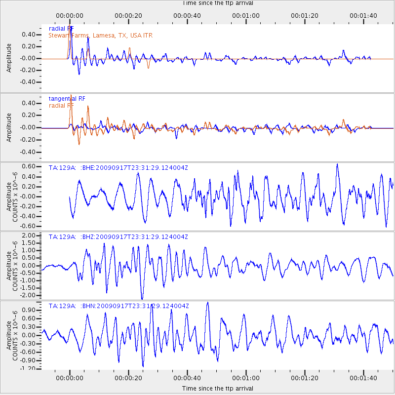
Signal To Noise
| Channel | StoN | STA | LTA |
| TA:129A: :BHZ:20090917T23:31:29.124004Z | 3.215626 | 4.3172616E-7 | 1.3425883E-7 |
| TA:129A: :BHN:20090917T23:31:29.124004Z | 2.1091938 | 2.7186354E-7 | 1.2889453E-7 |
| TA:129A: :BHE:20090917T23:31:29.124004Z | 0.931984 | 1.8072946E-7 | 1.9391906E-7 |
| Arrivals |
| Ps | 6.1 SECOND |
| PpPs | 16 SECOND |
| PsPs/PpSs | 22 SECOND |


