You are here: Home > Network List > TA - USArray Transportable Network (new EarthScope stations) Stations List
> Station 129A Stewart Farms, Lamesa, TX, USA > Earthquake Result Viewer
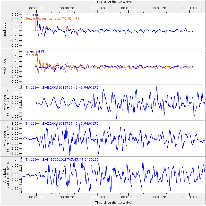
129A Stewart Farms, Lamesa, TX, USA - Earthquake Result Viewer
| Earthquake location: |
Fox Islands, Aleutian Islands |
| Earthquake latitude/longitude: |
52.8/-167.0 |
| Earthquake time(UTC): |
2009/10/13 (286) 05:37:23 GMT |
| Earthquake Depth: |
24 km |
| Earthquake Magnitude: |
6.0 MB, 6.1 MS, 6.5 MW, 6.5 MW |
| Earthquake Catalog/Contributor: |
WHDF/NEIC |
|
| Network: |
TA USArray Transportable Network (new EarthScope stations) |
| Station: |
129A Stewart Farms, Lamesa, TX, USA |
| Lat/Lon: |
32.63 N/101.87 W |
| Elevation: |
876 m |
|
| Distance: |
50.1 deg |
| Az: |
86.681 deg |
| Baz: |
314.018 deg |
| Ray Param: |
0.068261735 |
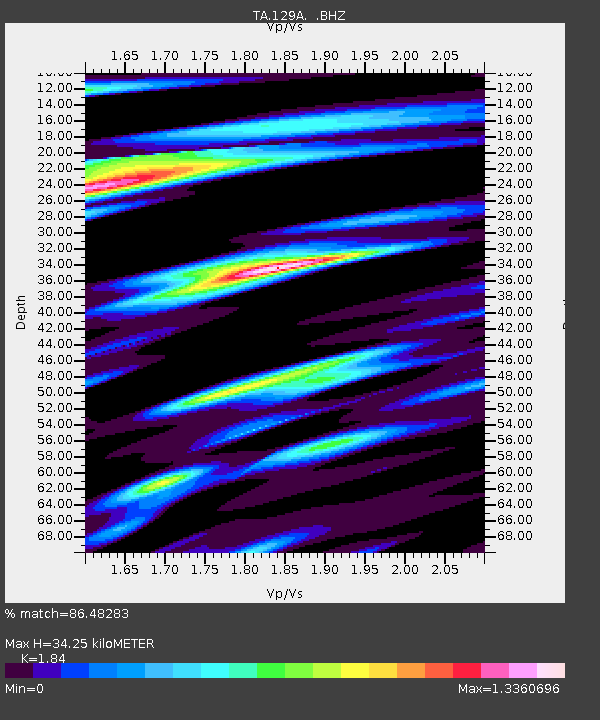
| Estimated Moho Depth: |
34.25 km |
| Estimated Crust Vp/Vs: |
1.84 |
| Assumed Crust Vp: |
6.426 km/s |
| Estimated Crust Vs: |
3.492 km/s |
| Estimated Crust Poisson's Ratio: |
0.29 |
|
| Radial Match: |
86.48283 % |
| Radial Bump: |
400 |
| Transverse Match: |
61.76771 % |
| Transverse Bump: |
400 |
| SOD ConfigId: |
2622 |
| Insert Time: |
2010-03-05 23:15:45.750 +0000 |
| GWidth: |
2.5 |
| Max Bumps: |
400 |
| Tol: |
0.001 |
|
Signal To Noise
| Channel | StoN | STA | LTA |
| TA:129A: :BHZ:20091013T05:45:45.649015Z | 2.7818666 | 6.4327423E-7 | 2.3123833E-7 |
| TA:129A: :BHN:20091013T05:45:45.649015Z | 0.89353794 | 1.6900988E-7 | 1.8914683E-7 |
| TA:129A: :BHE:20091013T05:45:45.649015Z | 1.1124945 | 3.4611276E-7 | 3.1111415E-7 |
| Arrivals |
| Ps | 4.7 SECOND |
| PpPs | 14 SECOND |
| PsPs/PpSs | 19 SECOND |


