You are here: Home > Network List > TA - USArray Transportable Network (new EarthScope stations) Stations List
> Station 129A Stewart Farms, Lamesa, TX, USA > Earthquake Result Viewer
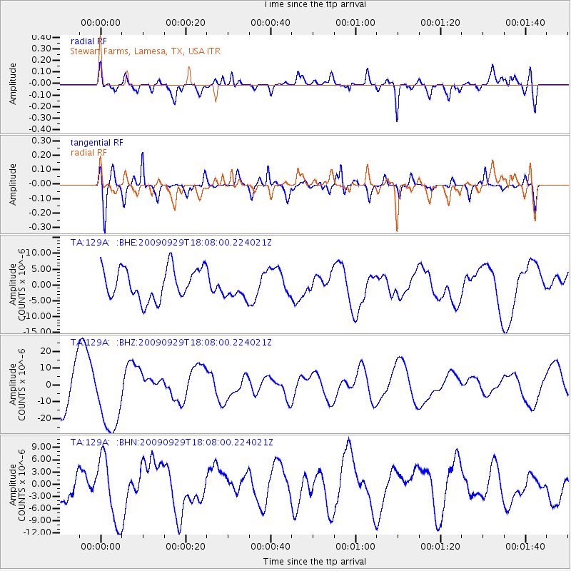
129A Stewart Farms, Lamesa, TX, USA - Earthquake Result Viewer
*The percent match for this event was below the threshold and hence no stack was calculated.
| Earthquake location: |
Tonga Islands |
| Earthquake latitude/longitude: |
-15.4/-173.2 |
| Earthquake time(UTC): |
2009/09/29 (272) 17:56:05 GMT |
| Earthquake Depth: |
10 km |
| Earthquake Magnitude: |
6.0 MB |
| Earthquake Catalog/Contributor: |
WHDF/NEIC |
|
| Network: |
TA USArray Transportable Network (new EarthScope stations) |
| Station: |
129A Stewart Farms, Lamesa, TX, USA |
| Lat/Lon: |
32.63 N/101.87 W |
| Elevation: |
876 m |
|
| Distance: |
83.1 deg |
| Az: |
53.613 deg |
| Baz: |
246.988 deg |
| Ray Param: |
$rayparam |
*The percent match for this event was below the threshold and hence was not used in the summary stack. |
|
| Radial Match: |
55.42365 % |
| Radial Bump: |
400 |
| Transverse Match: |
73.923874 % |
| Transverse Bump: |
376 |
| SOD ConfigId: |
2622 |
| Insert Time: |
2010-03-05 23:16:14.685 +0000 |
| GWidth: |
2.5 |
| Max Bumps: |
400 |
| Tol: |
0.001 |
|
Signal To Noise
| Channel | StoN | STA | LTA |
| TA:129A: :BHZ:20090929T18:08:00.224021Z | 1.7449945 | 2.0775251E-5 | 1.1905626E-5 |
| TA:129A: :BHN:20090929T18:08:00.224021Z | 1.8203325 | 8.0558275E-6 | 4.4254703E-6 |
| TA:129A: :BHE:20090929T18:08:00.224021Z | 0.81418365 | 4.0020095E-6 | 4.915365E-6 |
| Arrivals |
| Ps | |
| PpPs | |
| PsPs/PpSs | |


