You are here: Home > Network List > TA - USArray Transportable Network (new EarthScope stations) Stations List
> Station 129A Stewart Farms, Lamesa, TX, USA > Earthquake Result Viewer
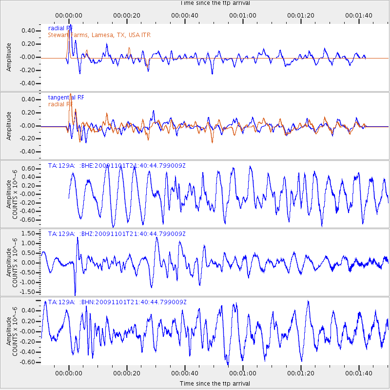
129A Stewart Farms, Lamesa, TX, USA - Earthquake Result Viewer
*The percent match for this event was below the threshold and hence no stack was calculated.
| Earthquake location: |
Tonga Islands |
| Earthquake latitude/longitude: |
-15.5/-173.8 |
| Earthquake time(UTC): |
2009/11/01 (305) 21:28:58 GMT |
| Earthquake Depth: |
105 km |
| Earthquake Magnitude: |
5.8 MW, 5.4 MB, 5.8 MW |
| Earthquake Catalog/Contributor: |
WHDF/NEIC |
|
| Network: |
TA USArray Transportable Network (new EarthScope stations) |
| Station: |
129A Stewart Farms, Lamesa, TX, USA |
| Lat/Lon: |
32.63 N/101.87 W |
| Elevation: |
876 m |
|
| Distance: |
83.7 deg |
| Az: |
53.795 deg |
| Baz: |
247.209 deg |
| Ray Param: |
$rayparam |
*The percent match for this event was below the threshold and hence was not used in the summary stack. |
|
| Radial Match: |
72.06478 % |
| Radial Bump: |
400 |
| Transverse Match: |
66.04419 % |
| Transverse Bump: |
400 |
| SOD ConfigId: |
2622 |
| Insert Time: |
2010-03-05 23:16:22.291 +0000 |
| GWidth: |
2.5 |
| Max Bumps: |
400 |
| Tol: |
0.001 |
|
Signal To Noise
| Channel | StoN | STA | LTA |
| TA:129A: :BHZ:20091101T21:40:44.799009Z | 1.6694655 | 5.8289976E-7 | 3.491535E-7 |
| TA:129A: :BHN:20091101T21:40:44.799009Z | 0.9990724 | 2.9604314E-7 | 2.9631803E-7 |
| TA:129A: :BHE:20091101T21:40:44.799009Z | 0.71877146 | 2.897086E-7 | 4.0306077E-7 |
| Arrivals |
| Ps | |
| PpPs | |
| PsPs/PpSs | |


