You are here: Home > Network List > TA - USArray Transportable Network (new EarthScope stations) Stations List
> Station P27A Ficken Ranch, Kirk, CO, USA > Earthquake Result Viewer
P27A Ficken Ranch, Kirk, CO, USA - Earthquake Result Viewer
| Earthquake location: |
Near Coast Of Venezuela |
| Earthquake latitude/longitude: |
10.7/-67.9 |
| Earthquake time(UTC): |
2009/09/12 (255) 20:06:24 GMT |
| Earthquake Depth: |
10 km |
| Earthquake Magnitude: |
6.3 MB, 6.4 MS, 6.3 MW, 6.3 MW |
| Earthquake Catalog/Contributor: |
WHDF/NEIC |
|
| Network: |
TA USArray Transportable Network (new EarthScope stations) |
| Station: |
P27A Ficken Ranch, Kirk, CO, USA |
| Lat/Lon: |
39.56 N/102.58 W |
| Elevation: |
1286 m |
|
| Distance: |
42.1 deg |
| Az: |
319.016 deg |
| Baz: |
123.512 deg |
| Ray Param: |
0.07337457 |
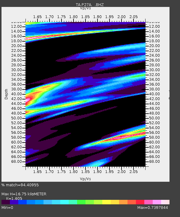
| Estimated Moho Depth: |
16.75 km |
| Estimated Crust Vp/Vs: |
1.61 |
| Assumed Crust Vp: |
6.242 km/s |
| Estimated Crust Vs: |
3.889 km/s |
| Estimated Crust Poisson's Ratio: |
0.18 |
|
| Radial Match: |
94.40955 % |
| Radial Bump: |
207 |
| Transverse Match: |
55.10444 % |
| Transverse Bump: |
256 |
| SOD ConfigId: |
2622 |
| Insert Time: |
2010-03-05 23:16:40.765 +0000 |
| GWidth: |
2.5 |
| Max Bumps: |
400 |
| Tol: |
0.001 |
|
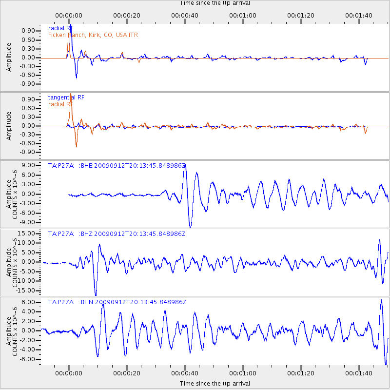
Signal To Noise
| Channel | StoN | STA | LTA |
| TA:P27A: :BHZ:20090912T20:13:45.848986Z | 8.946746 | 1.3649131E-6 | 1.5255974E-7 |
| TA:P27A: :BHN:20090912T20:13:45.848986Z | 1.6180885 | 5.1918573E-7 | 3.2086362E-7 |
| TA:P27A: :BHE:20090912T20:13:45.848986Z | 3.2152004 | 7.610837E-7 | 2.3671423E-7 |
| Arrivals |
| Ps | 1.7 SECOND |
| PpPs | 6.5 SECOND |
| PsPs/PpSs | 8.3 SECOND |


