You are here: Home > Network List > TA - USArray Transportable Network (new EarthScope stations) Stations List
> Station P27A Ficken Ranch, Kirk, CO, USA > Earthquake Result Viewer
P27A Ficken Ranch, Kirk, CO, USA - Earthquake Result Viewer
| Earthquake location: |
East Of Severnaya Zemlya |
| Earthquake latitude/longitude: |
81.6/119.5 |
| Earthquake time(UTC): |
2009/10/07 (280) 20:52:13 GMT |
| Earthquake Depth: |
8.0 km |
| Earthquake Magnitude: |
5.7 MB, 5.1 MS, 5.8 MW, 5.8 MW |
| Earthquake Catalog/Contributor: |
WHDF/NEIC |
|
| Network: |
TA USArray Transportable Network (new EarthScope stations) |
| Station: |
P27A Ficken Ranch, Kirk, CO, USA |
| Lat/Lon: |
39.56 N/102.58 W |
| Elevation: |
1286 m |
|
| Distance: |
57.1 deg |
| Az: |
38.114 deg |
| Baz: |
353.236 deg |
| Ray Param: |
0.063692555 |
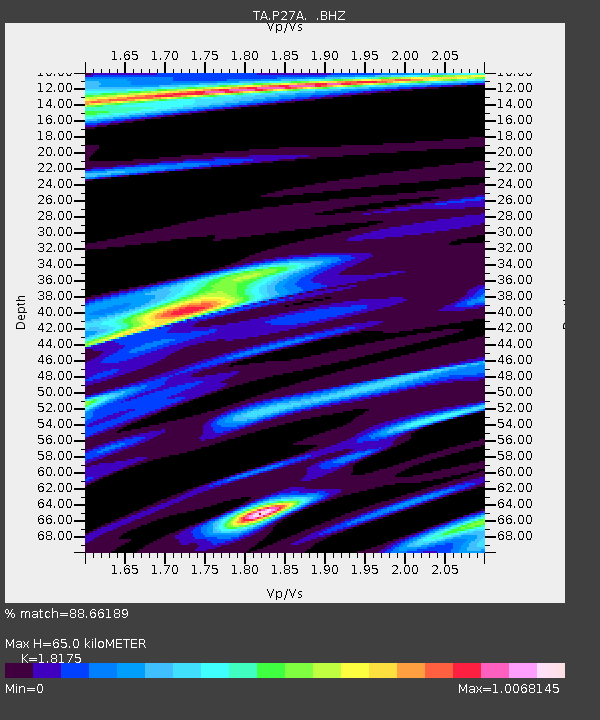
| Estimated Moho Depth: |
65.0 km |
| Estimated Crust Vp/Vs: |
1.82 |
| Assumed Crust Vp: |
6.242 km/s |
| Estimated Crust Vs: |
3.434 km/s |
| Estimated Crust Poisson's Ratio: |
0.28 |
|
| Radial Match: |
88.66189 % |
| Radial Bump: |
396 |
| Transverse Match: |
57.325047 % |
| Transverse Bump: |
400 |
| SOD ConfigId: |
2622 |
| Insert Time: |
2010-03-05 23:16:43.315 +0000 |
| GWidth: |
2.5 |
| Max Bumps: |
400 |
| Tol: |
0.001 |
|
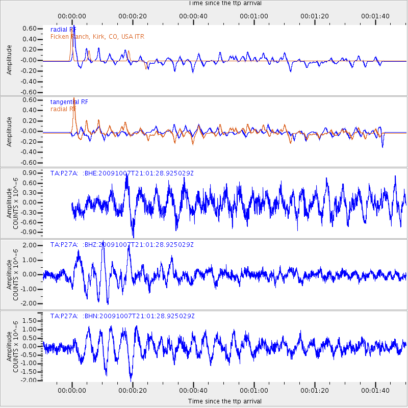
Signal To Noise
| Channel | StoN | STA | LTA |
| TA:P27A: :BHZ:20091007T21:01:28.925029Z | 5.068811 | 8.17963E-7 | 1.6137177E-7 |
| TA:P27A: :BHN:20091007T21:01:28.925029Z | 2.3285458 | 4.8294623E-7 | 2.0740251E-7 |
| TA:P27A: :BHE:20091007T21:01:28.925029Z | 1.1256886 | 3.3164142E-7 | 2.9461205E-7 |
| Arrivals |
| Ps | 8.9 SECOND |
| PpPs | 28 SECOND |
| PsPs/PpSs | 37 SECOND |


