You are here: Home > Network List > TA - USArray Transportable Network (new EarthScope stations) Stations List
> Station P27A Ficken Ranch, Kirk, CO, USA > Earthquake Result Viewer
P27A Ficken Ranch, Kirk, CO, USA - Earthquake Result Viewer
| Earthquake location: |
Baffin Bay |
| Earthquake latitude/longitude: |
75.4/-72.5 |
| Earthquake time(UTC): |
2009/07/07 (188) 19:11:46 GMT |
| Earthquake Depth: |
19 km |
| Earthquake Magnitude: |
5.9 MB, 5.7 MS, 6.1 MW, 6.0 MW |
| Earthquake Catalog/Contributor: |
WHDF/NEIC |
|
| Network: |
TA USArray Transportable Network (new EarthScope stations) |
| Station: |
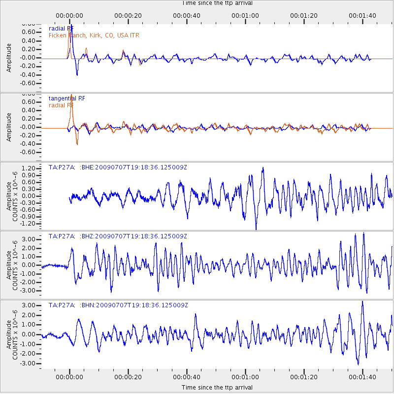
P27A Ficken Ranch, Kirk, CO, USA |
| Lat/Lon: |
39.56 N/102.58 W |
| Elevation: |
1286 m |
|
| Distance: |
38.4 deg |
| Az: |
218.647 deg |
| Baz: |
11.864 deg |
| Ray Param: |
0.07555458 |
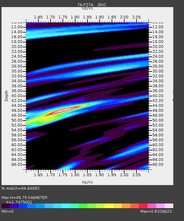
| Estimated Moho Depth: |
45.75 km |
| Estimated Crust Vp/Vs: |
1.75 |
| Assumed Crust Vp: |
6.242 km/s |
| Estimated Crust Vs: |
3.572 km/s |
| Estimated Crust Poisson's Ratio: |
0.26 |
|
| Radial Match: |
84.64892 % |
| Radial Bump: |
296 |
| Transverse Match: |
67.53731 % |
| Transverse Bump: |
400 |
| SOD ConfigId: |
2648 |
| Insert Time: |
2010-03-05 23:16:48.678 +0000 |
| GWidth: |
2.5 |
| Max Bumps: |
400 |
| Tol: |
0.001 |
|
Signal To Noise
| Channel | StoN | STA | LTA |
| TA:P27A: :BHZ:20090707T19:18:36.125009Z | 10.71788 | 1.2630759E-6 | 1.1784755E-7 |
| TA:P27A: :BHN:20090707T19:18:36.125009Z | 4.517891 | 8.627074E-7 | 1.9095357E-7 |
| TA:P27A: :BHE:20090707T19:18:36.125009Z | 1.7885902 | 3.129759E-7 | 1.749847E-7 |
| Arrivals |
| Ps | 5.9 SECOND |
| PpPs | 19 SECOND |
| PsPs/PpSs | 25 SECOND |


