You are here: Home > Network List > TA - USArray Transportable Network (new EarthScope stations) Stations List
> Station P27A Ficken Ranch, Kirk, CO, USA > Earthquake Result Viewer
P27A Ficken Ranch, Kirk, CO, USA - Earthquake Result Viewer

| Earthquake location: |
Off Coast Of Ecuador |
| Earthquake latitude/longitude: |
1.4/-85.2 |
| Earthquake time(UTC): |
2009/05/10 (130) 01:16:06 GMT |
| Earthquake Depth: |
6.0 km |
| Earthquake Magnitude: |
5.5 MB, 5.7 MS, 6.1 MW, 6.1 MW |
| Earthquake Catalog/Contributor: |
WHDF/NEIC |
|
| Network: |
TA USArray Transportable Network (new EarthScope stations) |
| Station: |
P27A Ficken Ranch, Kirk, CO, USA |
| Lat/Lon: |
39.56 N/102.58 W |
| Elevation: |
1286 m |
|
| Distance: |
41.2 deg |
| Az: |
339.428 deg |
| Baz: |
152.975 deg |
| Ray Param: |
0.07397249 |
| Estimated Moho Depth: |
46.0 km |
| Estimated Crust Vp/Vs: |
1.71 |
| Assumed Crust Vp: |
6.242 km/s |
| Estimated Crust Vs: |
3.65 km/s |
| Estimated Crust Poisson's Ratio: |
0.24 |
|
| Radial Match: |
92.03277 % |
| Radial Bump: |
278 |
| Transverse Match: |
66.63815 % |
| Transverse Bump: |
400 |
| SOD ConfigId: |
2760 |
| Insert Time: |
2010-03-05 23:16:51.376 +0000 |
| GWidth: |
2.5 |
| Max Bumps: |
400 |
| Tol: |
0.001 |
|
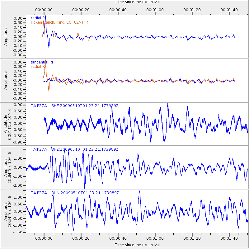
Signal To Noise
| Channel | StoN | STA | LTA |
| TA:P27A: :BHZ:20090510T01:23:21.173989Z | 7.9172 | 8.2023485E-7 | 1.0360163E-7 |
| TA:P27A: :BHN:20090510T01:23:21.173989Z | 2.4052422 | 4.339326E-7 | 1.8041118E-7 |
| TA:P27A: :BHE:20090510T01:23:21.173989Z | 1.48439 | 2.3407073E-7 | 1.5768816E-7 |
| Arrivals |
| Ps | 5.6 SECOND |
| PpPs | 19 SECOND |
| PsPs/PpSs | 24 SECOND |


