You are here: Home > Network List > TA - USArray Transportable Network (new EarthScope stations) Stations List
> Station P27A Ficken Ranch, Kirk, CO, USA > Earthquake Result Viewer
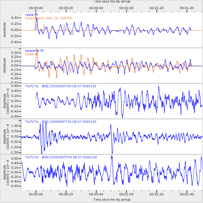
P27A Ficken Ranch, Kirk, CO, USA - Earthquake Result Viewer
*The percent match for this event was below the threshold and hence no stack was calculated.
| Earthquake location: |
Southern Peru |
| Earthquake latitude/longitude: |
-15.1/-70.2 |
| Earthquake time(UTC): |
2009/09/05 (248) 03:58:39 GMT |
| Earthquake Depth: |
210 km |
| Earthquake Magnitude: |
5.8 MW, 5.2 MB, 5.8 MW |
| Earthquake Catalog/Contributor: |
WHDF/NEIC |
|
| Network: |
TA USArray Transportable Network (new EarthScope stations) |
| Station: |
P27A Ficken Ranch, Kirk, CO, USA |
| Lat/Lon: |
39.56 N/102.58 W |
| Elevation: |
1286 m |
|
| Distance: |
62.2 deg |
| Az: |
332.133 deg |
| Baz: |
144.271 deg |
| Ray Param: |
$rayparam |
*The percent match for this event was below the threshold and hence was not used in the summary stack. |
|
| Radial Match: |
74.29895 % |
| Radial Bump: |
336 |
| Transverse Match: |
59.26313 % |
| Transverse Bump: |
400 |
| SOD ConfigId: |
2622 |
| Insert Time: |
2010-03-05 23:16:58.488 +0000 |
| GWidth: |
2.5 |
| Max Bumps: |
400 |
| Tol: |
0.001 |
|
Signal To Noise
| Channel | StoN | STA | LTA |
| TA:P27A: :BHZ:20090905T04:08:07.699014Z | 5.999757 | 6.615537E-7 | 1.10263414E-7 |
| TA:P27A: :BHN:20090905T04:08:07.699014Z | 1.0058837 | 1.956998E-7 | 1.9455508E-7 |
| TA:P27A: :BHE:20090905T04:08:07.699014Z | 1.593055 | 1.8698702E-7 | 1.1737637E-7 |
| Arrivals |
| Ps | |
| PpPs | |
| PsPs/PpSs | |


