You are here: Home > Network List > TA - USArray Transportable Network (new EarthScope stations) Stations List
> Station P27A Ficken Ranch, Kirk, CO, USA > Earthquake Result Viewer
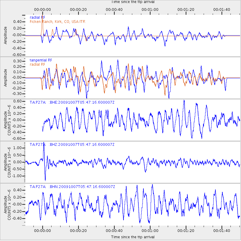
P27A Ficken Ranch, Kirk, CO, USA - Earthquake Result Viewer
*The percent match for this event was below the threshold and hence no stack was calculated.
| Earthquake location: |
Rat Islands, Aleutian Islands |
| Earthquake latitude/longitude: |
52.2/178.1 |
| Earthquake time(UTC): |
2009/10/07 (280) 05:38:37 GMT |
| Earthquake Depth: |
138 km |
| Earthquake Magnitude: |
5.6 MB, 5.6 MW, 5.6 MW |
| Earthquake Catalog/Contributor: |
WHDF/NEIC |
|
| Network: |
TA USArray Transportable Network (new EarthScope stations) |
| Station: |
P27A Ficken Ranch, Kirk, CO, USA |
| Lat/Lon: |
39.56 N/102.58 W |
| Elevation: |
1286 m |
|
| Distance: |
54.0 deg |
| Az: |
69.875 deg |
| Baz: |
311.563 deg |
| Ray Param: |
$rayparam |
*The percent match for this event was below the threshold and hence was not used in the summary stack. |
|
| Radial Match: |
52.026318 % |
| Radial Bump: |
345 |
| Transverse Match: |
52.325058 % |
| Transverse Bump: |
361 |
| SOD ConfigId: |
2622 |
| Insert Time: |
2010-03-05 23:17:14.002 +0000 |
| GWidth: |
2.5 |
| Max Bumps: |
400 |
| Tol: |
0.001 |
|
Signal To Noise
| Channel | StoN | STA | LTA |
| TA:P27A: :BHZ:20091007T05:47:16.600007Z | 7.1136494 | 5.4740707E-7 | 7.695165E-8 |
| TA:P27A: :BHN:20091007T05:47:16.600007Z | 0.8686751 | 2.0727954E-7 | 2.3861574E-7 |
| TA:P27A: :BHE:20091007T05:47:16.600007Z | 1.1149855 | 2.3558782E-7 | 2.1129227E-7 |
| Arrivals |
| Ps | |
| PpPs | |
| PsPs/PpSs | |


