You are here: Home > Network List > CI - Caltech Regional Seismic Network Stations List
> Station MWC Mount Wilson Obsv, Altadena, CA, USA > Earthquake Result Viewer
MWC Mount Wilson Obsv, Altadena, CA, USA - Earthquake Result Viewer
| Earthquake location: |
Santiago Del Estero Prov., Arg. |
| Earthquake latitude/longitude: |
-28.3/-63.0 |
| Earthquake time(UTC): |
2000/04/23 (114) 09:27:23 GMT |
| Earthquake Depth: |
608 km |
| Earthquake Magnitude: |
6.6 MB, 7.0 MW, 7.0 MW |
| Earthquake Catalog/Contributor: |
WHDF/NEIC |
|
| Network: |
CI Caltech Regional Seismic Network |
| Station: |
MWC Mount Wilson Obsv, Altadena, CA, USA |
| Lat/Lon: |
34.22 N/118.06 W |
| Elevation: |
1725 m |
|
| Distance: |
81.1 deg |
| Az: |
316.564 deg |
| Baz: |
132.976 deg |
| Ray Param: |
0.045930553 |
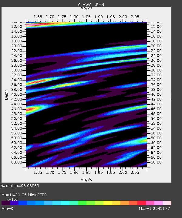
| Estimated Moho Depth: |
11.25 km |
| Estimated Crust Vp/Vs: |
1.60 |
| Assumed Crust Vp: |
6.1 km/s |
| Estimated Crust Vs: |
3.812 km/s |
| Estimated Crust Poisson's Ratio: |
0.18 |
|
| Radial Match: |
95.95868 % |
| Radial Bump: |
400 |
| Transverse Match: |
91.51146 % |
| Transverse Bump: |
400 |
| SOD ConfigId: |
3744 |
| Insert Time: |
2010-02-26 01:07:48.370 +0000 |
| GWidth: |
2.5 |
| Max Bumps: |
400 |
| Tol: |
0.001 |
|

Signal To Noise
| Channel | StoN | STA | LTA |
| CI:MWC: :BHN:20000423T09:38:05.35302Z | 11.1671715 | 2.1438511E-6 | 1.9197799E-7 |
| CI:MWC: :BHE:20000423T09:38:05.35302Z | 15.399768 | 2.765689E-6 | 1.795929E-7 |
| CI:MWC: :BHZ:20000423T09:38:05.35302Z | 47.14604 | 8.2284705E-6 | 1.7453151E-7 |
| Arrivals |
| Ps | 1.1 SECOND |
| PpPs | 4.7 SECOND |
| PsPs/PpSs | 5.8 SECOND |


