You are here: Home > Network List > TA - USArray Transportable Network (new EarthScope stations) Stations List
> Station P27A Ficken Ranch, Kirk, CO, USA > Earthquake Result Viewer
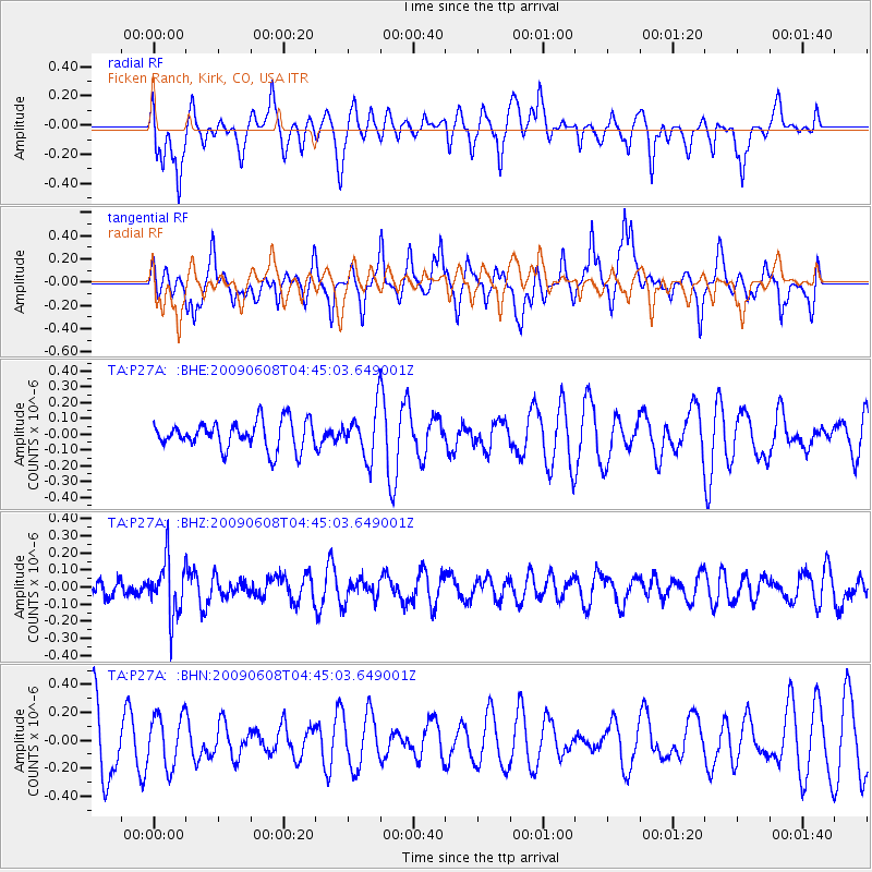
P27A Ficken Ranch, Kirk, CO, USA - Earthquake Result Viewer
*The percent match for this event was below the threshold and hence no stack was calculated.
| Earthquake location: |
South Of Fiji Islands |
| Earthquake latitude/longitude: |
-22.2/-179.6 |
| Earthquake time(UTC): |
2009/06/08 (159) 04:33:19 GMT |
| Earthquake Depth: |
612 km |
| Earthquake Magnitude: |
5.5 MW, 5.2 MB |
| Earthquake Catalog/Contributor: |
WHDF/NEIC |
|
| Network: |
TA USArray Transportable Network (new EarthScope stations) |
| Station: |
P27A Ficken Ranch, Kirk, CO, USA |
| Lat/Lon: |
39.56 N/102.58 W |
| Elevation: |
1286 m |
|
| Distance: |
94.5 deg |
| Az: |
49.085 deg |
| Baz: |
244.913 deg |
| Ray Param: |
$rayparam |
*The percent match for this event was below the threshold and hence was not used in the summary stack. |
|
| Radial Match: |
33.329475 % |
| Radial Bump: |
389 |
| Transverse Match: |
60.311783 % |
| Transverse Bump: |
397 |
| SOD ConfigId: |
2648 |
| Insert Time: |
2010-03-05 23:17:22.403 +0000 |
| GWidth: |
2.5 |
| Max Bumps: |
400 |
| Tol: |
0.001 |
|
Signal To Noise
| Channel | StoN | STA | LTA |
| TA:P27A: :BHZ:20090608T04:45:03.649001Z | 2.3929543 | 1.6437905E-7 | 6.869293E-8 |
| TA:P27A: :BHN:20090608T04:45:03.649001Z | 0.7436415 | 1.823281E-7 | 2.4518278E-7 |
| TA:P27A: :BHE:20090608T04:45:03.649001Z | 1.693155 | 1.5114449E-7 | 8.926795E-8 |
| Arrivals |
| Ps | |
| PpPs | |
| PsPs/PpSs | |


