You are here: Home > Network List > TA - USArray Transportable Network (new EarthScope stations) Stations List
> Station 128A Castleberry Farm, Seminole, TX, USA > Earthquake Result Viewer
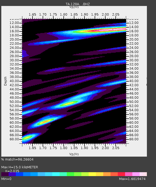
128A Castleberry Farm, Seminole, TX, USA - Earthquake Result Viewer
| Earthquake location: |
Norwegian Sea |
| Earthquake latitude/longitude: |
72.2/0.9 |
| Earthquake time(UTC): |
2009/08/20 (232) 06:35:04 GMT |
| Earthquake Depth: |
6.0 km |
| Earthquake Magnitude: |
5.9 MB, 5.7 MS, 6.0 MW, 6.0 MW |
| Earthquake Catalog/Contributor: |
WHDF/NEIC |
|
| Network: |
TA USArray Transportable Network (new EarthScope stations) |
| Station: |
128A Castleberry Farm, Seminole, TX, USA |
| Lat/Lon: |
32.62 N/102.49 W |
| Elevation: |
966 m |
|
| Distance: |
63.2 deg |
| Az: |
293.182 deg |
| Baz: |
19.574 deg |
| Ray Param: |
0.059712954 |
| Estimated Moho Depth: |
15.0 km |
| Estimated Crust Vp/Vs: |
2.04 |
| Assumed Crust Vp: |
6.129 km/s |
| Estimated Crust Vs: |
3.012 km/s |
| Estimated Crust Poisson's Ratio: |
0.34 |
|
| Radial Match: |
96.26604 % |
| Radial Bump: |
400 |
| Transverse Match: |
83.699165 % |
| Transverse Bump: |
400 |
| SOD ConfigId: |
2622 |
| Insert Time: |
2010-03-05 23:17:37.535 +0000 |
| GWidth: |
2.5 |
| Max Bumps: |
400 |
| Tol: |
0.001 |
|

Signal To Noise
| Channel | StoN | STA | LTA |
| TA:128A: :BHZ:20090820T06:45:02.45002Z | 20.962475 | 1.866238E-6 | 8.902756E-8 |
| TA:128A: :BHN:20090820T06:45:02.45002Z | 12.083471 | 8.909483E-7 | 7.3732814E-8 |
| TA:128A: :BHE:20090820T06:45:02.45002Z | 4.268055 | 3.4310426E-7 | 8.03889E-8 |
| Arrivals |
| Ps | 2.6 SECOND |
| PpPs | 7.2 SECOND |
| PsPs/PpSs | 9.8 SECOND |


