You are here: Home > Network List > TA - USArray Transportable Network (new EarthScope stations) Stations List
> Station 128A Castleberry Farm, Seminole, TX, USA > Earthquake Result Viewer
128A Castleberry Farm, Seminole, TX, USA - Earthquake Result Viewer
| Earthquake location: |
Santa Cruz Islands |
| Earthquake latitude/longitude: |
-12.6/166.0 |
| Earthquake time(UTC): |
2009/10/07 (280) 23:23:28 GMT |
| Earthquake Depth: |
36 km |
| Earthquake Magnitude: |
5.5 MB |
| Earthquake Catalog/Contributor: |
WHDF/NEIC |
|
| Network: |
TA USArray Transportable Network (new EarthScope stations) |
| Station: |
128A Castleberry Farm, Seminole, TX, USA |
| Lat/Lon: |
32.62 N/102.49 W |
| Elevation: |
966 m |
|
| Distance: |
98.0 deg |
| Az: |
58.405 deg |
| Baz: |
260.224 deg |
| Ray Param: |
0.040036432 |
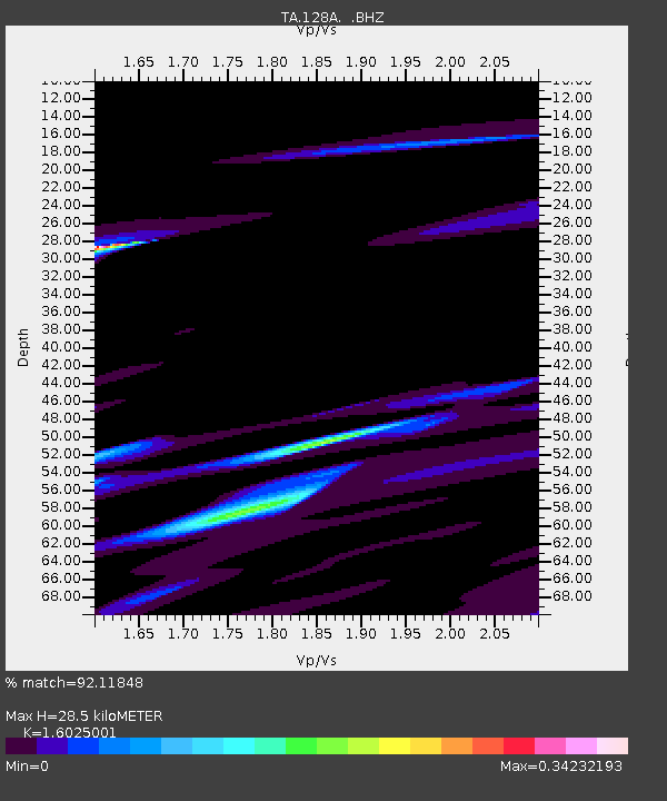
| Estimated Moho Depth: |
28.5 km |
| Estimated Crust Vp/Vs: |
1.60 |
| Assumed Crust Vp: |
6.129 km/s |
| Estimated Crust Vs: |
3.825 km/s |
| Estimated Crust Poisson's Ratio: |
0.18 |
|
| Radial Match: |
92.11848 % |
| Radial Bump: |
373 |
| Transverse Match: |
88.962975 % |
| Transverse Bump: |
347 |
| SOD ConfigId: |
2622 |
| Insert Time: |
2010-03-05 23:17:52.303 +0000 |
| GWidth: |
2.5 |
| Max Bumps: |
400 |
| Tol: |
0.001 |
|

Signal To Noise
| Channel | StoN | STA | LTA |
| TA:128A: :BHZ:20091007T23:36:29.274006Z | 1.2527641 | 4.9114187E-5 | 3.920466E-5 |
| TA:128A: :BHN:20091007T23:36:29.274006Z | 2.3492677 | 1.9935938E-5 | 8.486022E-6 |
| TA:128A: :BHE:20091007T23:36:29.274006Z | 1.2457157 | 2.2014234E-5 | 1.7671957E-5 |
| Arrivals |
| Ps | 2.9 SECOND |
| PpPs | 12 SECOND |
| PsPs/PpSs | 15 SECOND |


