You are here: Home > Network List > US - United States National Seismic Network Stations List
> Station MSO Missoula, Montana, USA > Earthquake Result Viewer
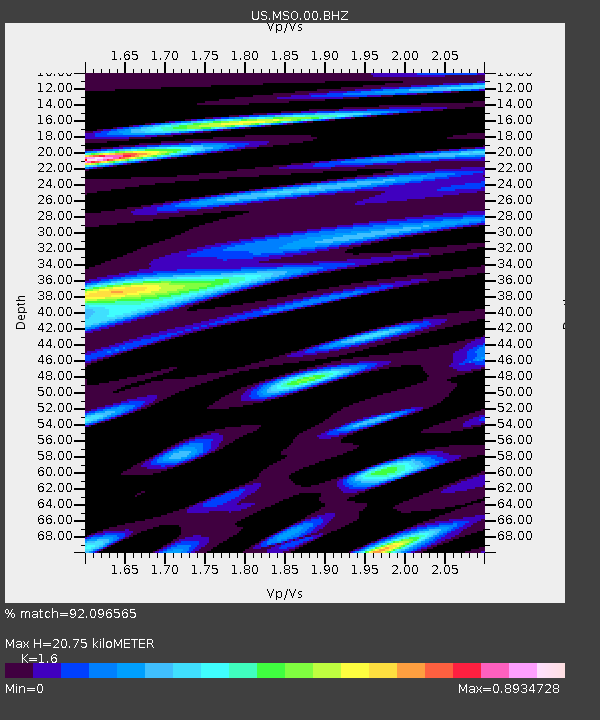
MSO Missoula, Montana, USA - Earthquake Result Viewer
| Earthquake location: |
Peru-Brazil Border Region |
| Earthquake latitude/longitude: |
-10.1/-71.1 |
| Earthquake time(UTC): |
2015/11/24 (328) 22:50:53 GMT |
| Earthquake Depth: |
595 km |
| Earthquake Magnitude: |
5.9 MB |
| Earthquake Catalog/Contributor: |
NEIC PDE/NEIC COMCAT |
|
| Network: |
US United States National Seismic Network |
| Station: |
MSO Missoula, Montana, USA |
| Lat/Lon: |
46.83 N/113.94 W |
| Elevation: |
1264 m |
|
| Distance: |
68.4 deg |
| Az: |
329.833 deg |
| Baz: |
133.889 deg |
| Ray Param: |
0.054239534 |
| Estimated Moho Depth: |
20.75 km |
| Estimated Crust Vp/Vs: |
1.60 |
| Assumed Crust Vp: |
6.353 km/s |
| Estimated Crust Vs: |
3.971 km/s |
| Estimated Crust Poisson's Ratio: |
0.18 |
|
| Radial Match: |
92.096565 % |
| Radial Bump: |
400 |
| Transverse Match: |
75.361595 % |
| Transverse Bump: |
400 |
| SOD ConfigId: |
1259291 |
| Insert Time: |
2015-12-09 00:06:17.517 +0000 |
| GWidth: |
2.5 |
| Max Bumps: |
400 |
| Tol: |
0.001 |
|

Signal To Noise
| Channel | StoN | STA | LTA |
| US:MSO:00:BHZ:20151124T23:00:25.174988Z | 13.874791 | 2.7914479E-5 | 2.0118846E-6 |
| US:MSO:00:BH1:20151124T23:00:25.174988Z | 6.7440057 | 9.442942E-6 | 1.4001979E-6 |
| US:MSO:00:BH2:20151124T23:00:25.174988Z | 7.501659 | 8.768913E-6 | 1.1689299E-6 |
| Arrivals |
| Ps | 2.0 SECOND |
| PpPs | 8.2 SECOND |
| PsPs/PpSs | 10 SECOND |


