You are here: Home > Network List > TA - USArray Transportable Network (new EarthScope stations) Stations List
> Station T25A Trinidad, CO, USA > Earthquake Result Viewer
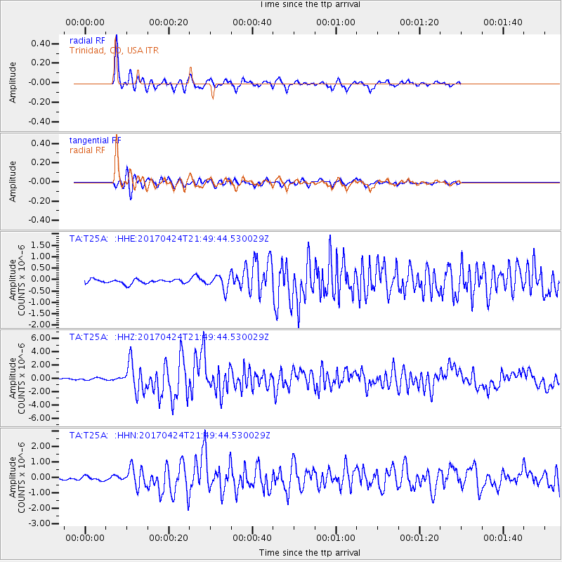
T25A Trinidad, CO, USA - Earthquake Result Viewer
*The percent match for this event was below the threshold and hence no stack was calculated.
| Earthquake location: |
Off Coast Of Central Chile |
| Earthquake latitude/longitude: |
-33.0/-72.0 |
| Earthquake time(UTC): |
2017/04/24 (114) 21:38:24 GMT |
| Earthquake Depth: |
33 km |
| Earthquake Magnitude: |
6.7 Mi |
| Earthquake Catalog/Contributor: |
NEIC PDE/at |
|
| Network: |
TA USArray Transportable Network (new EarthScope stations) |
| Station: |
T25A Trinidad, CO, USA |
| Lat/Lon: |
37.14 N/104.41 W |
| Elevation: |
2017 m |
|
| Distance: |
76.1 deg |
| Az: |
333.811 deg |
| Baz: |
152.348 deg |
| Ray Param: |
$rayparam |
*The percent match for this event was below the threshold and hence was not used in the summary stack. |
|
| Radial Match: |
95.14649 % |
| Radial Bump: |
287 |
| Transverse Match: |
88.0581 % |
| Transverse Bump: |
370 |
| SOD ConfigId: |
11737051 |
| Insert Time: |
2019-04-27 04:45:32.854 +0000 |
| GWidth: |
2.5 |
| Max Bumps: |
400 |
| Tol: |
0.001 |
|
Signal To Noise
| Channel | StoN | STA | LTA |
| TA:T25A: :HHZ:20170424T21:49:44.530029Z | 2.0629978 | 1.5881875E-7 | 7.698445E-8 |
| TA:T25A: :HHN:20170424T21:49:44.530029Z | 0.8880373 | 1.4883722E-7 | 1.6760242E-7 |
| TA:T25A: :HHE:20170424T21:49:44.530029Z | 1.7794117 | 1.7286129E-7 | 9.71452E-8 |
| Arrivals |
| Ps | |
| PpPs | |
| PsPs/PpSs | |


