You are here: Home > Network List > US - United States National Seismic Network Stations List
> Station AMTX Amarillo, Texas, USA > Earthquake Result Viewer
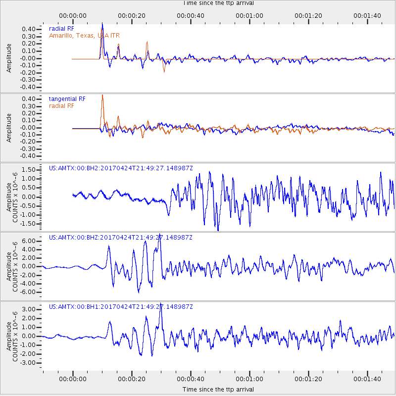
AMTX Amarillo, Texas, USA - Earthquake Result Viewer
*The percent match for this event was below the threshold and hence no stack was calculated.
| Earthquake location: |
Off Coast Of Central Chile |
| Earthquake latitude/longitude: |
-33.0/-72.0 |
| Earthquake time(UTC): |
2017/04/24 (114) 21:38:24 GMT |
| Earthquake Depth: |
33 km |
| Earthquake Magnitude: |
6.7 Mi |
| Earthquake Catalog/Contributor: |
NEIC PDE/at |
|
| Network: |
US United States National Seismic Network |
| Station: |
AMTX Amarillo, Texas, USA |
| Lat/Lon: |
34.53 N/101.41 W |
| Elevation: |
1010 m |
|
| Distance: |
72.6 deg |
| Az: |
334.864 deg |
| Baz: |
154.384 deg |
| Ray Param: |
$rayparam |
*The percent match for this event was below the threshold and hence was not used in the summary stack. |
|
| Radial Match: |
94.016685 % |
| Radial Bump: |
369 |
| Transverse Match: |
70.96878 % |
| Transverse Bump: |
400 |
| SOD ConfigId: |
11737051 |
| Insert Time: |
2019-04-27 04:46:20.820 +0000 |
| GWidth: |
2.5 |
| Max Bumps: |
400 |
| Tol: |
0.001 |
|
Signal To Noise
| Channel | StoN | STA | LTA |
| US:AMTX:00:BHZ:20170424T21:49:27.148987Z | 1.4981723 | 2.7298964E-7 | 1.822151E-7 |
| US:AMTX:00:BH1:20170424T21:49:27.148987Z | 1.3751065 | 1.7547868E-7 | 1.2761097E-7 |
| US:AMTX:00:BH2:20170424T21:49:27.148987Z | 1.7656149 | 2.401738E-7 | 1.360284E-7 |
| Arrivals |
| Ps | |
| PpPs | |
| PsPs/PpSs | |


