You are here: Home > Network List > US - United States National Seismic Network Stations List
> Station WMOK Wichita Mountains, Oklahoma, USA > Earthquake Result Viewer
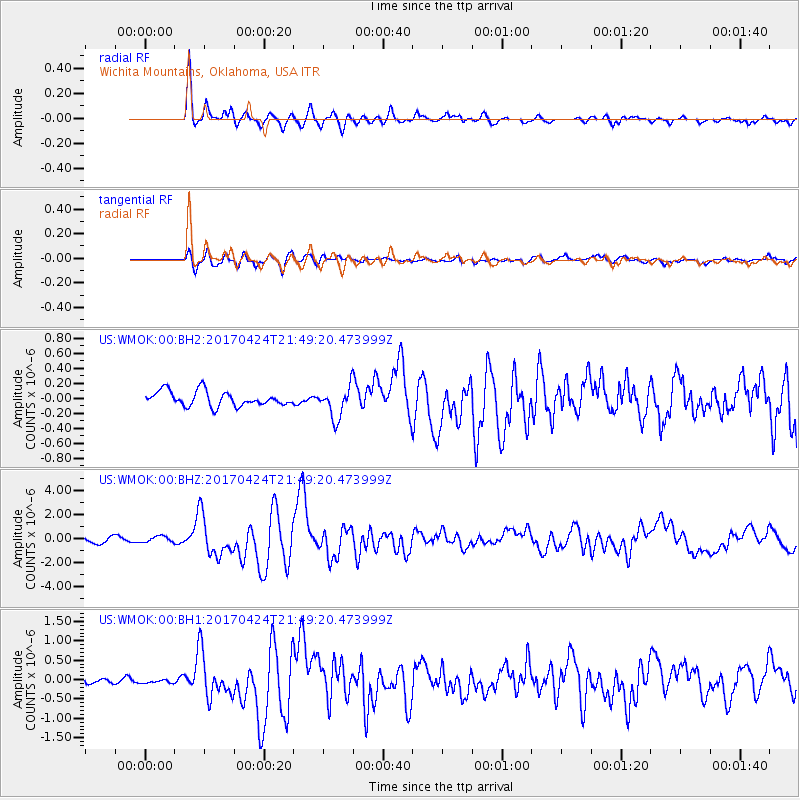
WMOK Wichita Mountains, Oklahoma, USA - Earthquake Result Viewer
*The percent match for this event was below the threshold and hence no stack was calculated.
| Earthquake location: |
Off Coast Of Central Chile |
| Earthquake latitude/longitude: |
-33.0/-72.0 |
| Earthquake time(UTC): |
2017/04/24 (114) 21:38:24 GMT |
| Earthquake Depth: |
33 km |
| Earthquake Magnitude: |
6.7 Mi |
| Earthquake Catalog/Contributor: |
NEIC PDE/at |
|
| Network: |
US United States National Seismic Network |
| Station: |
WMOK Wichita Mountains, Oklahoma, USA |
| Lat/Lon: |
34.74 N/98.78 W |
| Elevation: |
486 m |
|
| Distance: |
71.9 deg |
| Az: |
337.024 deg |
| Baz: |
156.528 deg |
| Ray Param: |
$rayparam |
*The percent match for this event was below the threshold and hence was not used in the summary stack. |
|
| Radial Match: |
94.54751 % |
| Radial Bump: |
400 |
| Transverse Match: |
85.67682 % |
| Transverse Bump: |
400 |
| SOD ConfigId: |
11737051 |
| Insert Time: |
2019-04-27 04:46:52.705 +0000 |
| GWidth: |
2.5 |
| Max Bumps: |
400 |
| Tol: |
0.001 |
|
Signal To Noise
| Channel | StoN | STA | LTA |
| US:WMOK:00:BHZ:20170424T21:49:20.473999Z | 0.9340783 | 2.562045E-7 | 2.742859E-7 |
| US:WMOK:00:BH1:20170424T21:49:20.473999Z | 0.46165106 | 4.320831E-8 | 9.3595176E-8 |
| US:WMOK:00:BH2:20170424T21:49:20.473999Z | 0.59173954 | 6.685349E-8 | 1.129779E-7 |
| Arrivals |
| Ps | |
| PpPs | |
| PsPs/PpSs | |


