You are here: Home > Network List > TA - USArray Transportable Network (new EarthScope stations) Stations List
> Station Z29A Hungry Hill Ranch, Wilson, TX, USA > Earthquake Result Viewer
Z29A Hungry Hill Ranch, Wilson, TX, USA - Earthquake Result Viewer
| Earthquake location: |
Kuril Islands |
| Earthquake latitude/longitude: |
48.3/154.2 |
| Earthquake time(UTC): |
2009/09/10 (253) 02:46:50 GMT |
| Earthquake Depth: |
36 km |
| Earthquake Magnitude: |
6.0 MB, 5.5 MS, 6.0 MW, 5.8 MW |
| Earthquake Catalog/Contributor: |
WHDF/NEIC |
|
| Network: |
TA USArray Transportable Network (new EarthScope stations) |
| Station: |
Z29A Hungry Hill Ranch, Wilson, TX, USA |
| Lat/Lon: |
33.26 N/101.71 W |
| Elevation: |
938 m |
|
| Distance: |
74.3 deg |
| Az: |
57.567 deg |
| Baz: |
317.748 deg |
| Ray Param: |
0.052354336 |
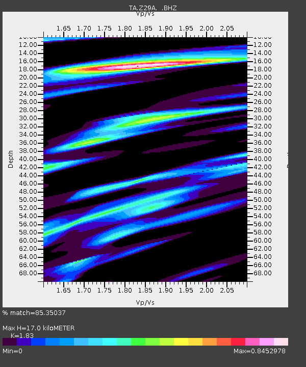
| Estimated Moho Depth: |
17.0 km |
| Estimated Crust Vp/Vs: |
1.83 |
| Assumed Crust Vp: |
6.426 km/s |
| Estimated Crust Vs: |
3.512 km/s |
| Estimated Crust Poisson's Ratio: |
0.29 |
|
| Radial Match: |
85.35037 % |
| Radial Bump: |
359 |
| Transverse Match: |
76.60533 % |
| Transverse Bump: |
400 |
| SOD ConfigId: |
2622 |
| Insert Time: |
2010-03-05 23:19:06.046 +0000 |
| GWidth: |
2.5 |
| Max Bumps: |
400 |
| Tol: |
0.001 |
|
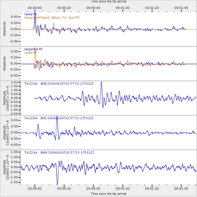
Signal To Noise
| Channel | StoN | STA | LTA |
| TA:Z29A: :BHZ:20090910T02:57:53.175012Z | 9.132968 | 1.1490383E-6 | 1.2581215E-7 |
| TA:Z29A: :BHN:20090910T02:57:53.175012Z | 1.1390417 | 1.8498152E-7 | 1.6240101E-7 |
| TA:Z29A: :BHE:20090910T02:57:53.175012Z | 2.5669355 | 4.42362E-7 | 1.7233077E-7 |
| Arrivals |
| Ps | 2.3 SECOND |
| PpPs | 7.2 SECOND |
| PsPs/PpSs | 9.5 SECOND |


