You are here: Home > Network List > CI - Caltech Regional Seismic Network Stations List
> Station MWC Mt. Wilson Observatory, Altadena, CA, USA > Earthquake Result Viewer
MWC Mt. Wilson Observatory, Altadena, CA, USA - Earthquake Result Viewer
| Earthquake location: |
New Ireland Region, P.N.G. |
| Earthquake latitude/longitude: |
-5.2/153.1 |
| Earthquake time(UTC): |
2000/11/16 (321) 08:12:20 GMT |
| Earthquake Depth: |
33 km |
| Earthquake Magnitude: |
5.5 MB |
| Earthquake Catalog/Contributor: |
WHDF/NEIC |
|
| Network: |
CI Caltech Regional Seismic Network |
| Station: |
MWC Mt. Wilson Observatory, Altadena, CA, USA |
| Lat/Lon: |
34.22 N/118.06 W |
| Elevation: |
1725 m |
|
| Distance: |
91.9 deg |
| Az: |
55.984 deg |
| Baz: |
265.026 deg |
| Ray Param: |
0.041528914 |
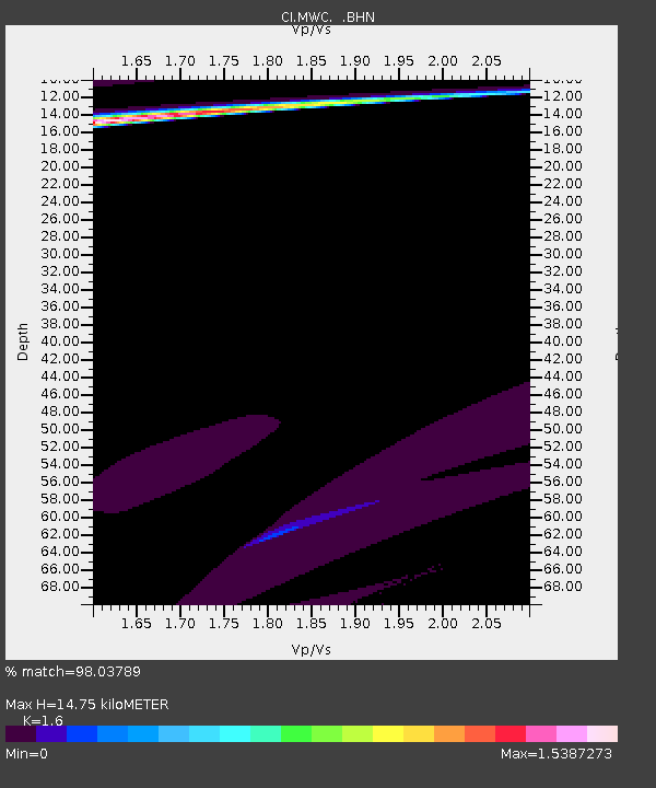
| Estimated Moho Depth: |
14.75 km |
| Estimated Crust Vp/Vs: |
1.60 |
| Assumed Crust Vp: |
6.1 km/s |
| Estimated Crust Vs: |
3.812 km/s |
| Estimated Crust Poisson's Ratio: |
0.18 |
|
| Radial Match: |
98.03789 % |
| Radial Bump: |
303 |
| Transverse Match: |
63.32947 % |
| Transverse Bump: |
400 |
| SOD ConfigId: |
3770 |
| Insert Time: |
2010-02-26 01:07:56.790 +0000 |
| GWidth: |
2.5 |
| Max Bumps: |
400 |
| Tol: |
0.001 |
|

Signal To Noise
| Channel | StoN | STA | LTA |
| CI:MWC: :BHN:20001116T08:24:53.843022Z | 0.40317714 | 2.8401726E-6 | 7.0444785E-6 |
| CI:MWC: :BHE:20001116T08:24:53.843022Z | 2.1258445 | 5.3109106E-5 | 2.4982593E-5 |
| CI:MWC: :BHZ:20001116T08:24:53.843022Z | 0.9953092 | 3.414738E-5 | 3.4308312E-5 |
| Arrivals |
| Ps | 1.5 SECOND |
| PpPs | 6.2 SECOND |
| PsPs/PpSs | 7.6 SECOND |


