You are here: Home > Network List > CI - Caltech Regional Seismic Network Stations List
> Station LRL Laurel Mtn Radio Fac, Ridgecrest, CA, USA > Earthquake Result Viewer
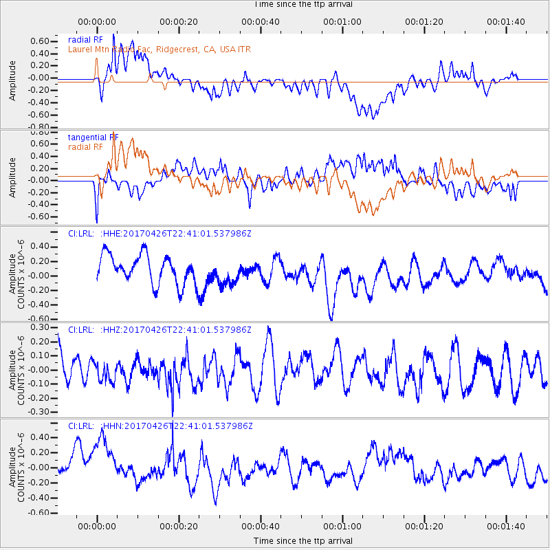
LRL Laurel Mtn Radio Fac, Ridgecrest, CA, USA - Earthquake Result Viewer
*The percent match for this event was below the threshold and hence no stack was calculated.
| Earthquake location: |
Pacific-Antarctic Ridge |
| Earthquake latitude/longitude: |
-54.9/-130.3 |
| Earthquake time(UTC): |
2017/04/26 (116) 22:28:30 GMT |
| Earthquake Depth: |
10 km |
| Earthquake Magnitude: |
5.5 Mwb |
| Earthquake Catalog/Contributor: |
NEIC PDE/us |
|
| Network: |
CI Caltech Regional Seismic Network |
| Station: |
LRL Laurel Mtn Radio Fac, Ridgecrest, CA, USA |
| Lat/Lon: |
35.48 N/117.68 W |
| Elevation: |
1340 m |
|
| Distance: |
90.6 deg |
| Az: |
10.273 deg |
| Baz: |
187.255 deg |
| Ray Param: |
$rayparam |
*The percent match for this event was below the threshold and hence was not used in the summary stack. |
|
| Radial Match: |
66.92502 % |
| Radial Bump: |
400 |
| Transverse Match: |
61.06949 % |
| Transverse Bump: |
400 |
| SOD ConfigId: |
11737051 |
| Insert Time: |
2019-04-27 04:59:36.662 +0000 |
| GWidth: |
2.5 |
| Max Bumps: |
400 |
| Tol: |
0.001 |
|
Signal To Noise
| Channel | StoN | STA | LTA |
| CI:LRL: :HHZ:20170426T22:41:01.537986Z | 0.48640496 | 7.093267E-8 | 1.4583048E-7 |
| CI:LRL: :HHN:20170426T22:41:01.537986Z | 2.029419 | 4.9604125E-7 | 2.4442528E-7 |
| CI:LRL: :HHE:20170426T22:41:01.537986Z | 0.92746896 | 1.8257519E-7 | 1.9685315E-7 |
| Arrivals |
| Ps | |
| PpPs | |
| PsPs/PpSs | |


