You are here: Home > Network List > WY - Yellowstone Wyoming Seismic Network Stations List
> Station YMP Mirror Lake Plateau, YNP, WY, USA > Earthquake Result Viewer
YMP Mirror Lake Plateau, YNP, WY, USA - Earthquake Result Viewer
| Earthquake location: |
Peru-Brazil Border Region |
| Earthquake latitude/longitude: |
-10.1/-71.1 |
| Earthquake time(UTC): |
2015/11/24 (328) 22:50:53 GMT |
| Earthquake Depth: |
595 km |
| Earthquake Magnitude: |
5.9 MB |
| Earthquake Catalog/Contributor: |
NEIC PDE/NEIC COMCAT |
|
| Network: |
WY Yellowstone Wyoming Seismic Network |
| Station: |
YMP Mirror Lake Plateau, YNP, WY, USA |
| Lat/Lon: |
44.74 N/110.16 W |
| Elevation: |
2774 m |
|
| Distance: |
65.0 deg |
| Az: |
330.285 deg |
| Baz: |
136.773 deg |
| Ray Param: |
0.05633082 |
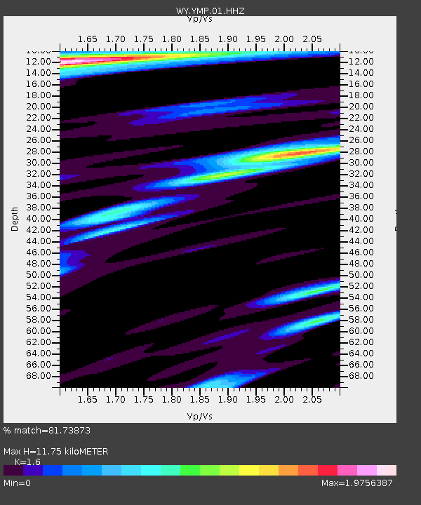
| Estimated Moho Depth: |
11.75 km |
| Estimated Crust Vp/Vs: |
1.60 |
| Assumed Crust Vp: |
6.35 km/s |
| Estimated Crust Vs: |
3.969 km/s |
| Estimated Crust Poisson's Ratio: |
0.18 |
|
| Radial Match: |
81.73873 % |
| Radial Bump: |
400 |
| Transverse Match: |
76.13109 % |
| Transverse Bump: |
400 |
| SOD ConfigId: |
1259291 |
| Insert Time: |
2015-12-09 00:10:20.289 +0000 |
| GWidth: |
2.5 |
| Max Bumps: |
400 |
| Tol: |
0.001 |
|

Signal To Noise
| Channel | StoN | STA | LTA |
| WY:YMP:01:HHZ:20151124T23:00:04.65802Z | 11.406236 | 7.760627E-7 | 6.803846E-8 |
| WY:YMP:01:HHN:20151124T23:00:04.65802Z | 4.564893 | 3.3062105E-7 | 7.242691E-8 |
| WY:YMP:01:HHE:20151124T23:00:04.65802Z | 5.7109175 | 4.2446686E-7 | 7.432551E-8 |
| Arrivals |
| Ps | 1.2 SECOND |
| PpPs | 4.6 SECOND |
| PsPs/PpSs | 5.8 SECOND |


