You are here: Home > Network List > TA - USArray Transportable Network (new EarthScope stations) Stations List
> Station W13A Hualapai Mountain Park, Kingman, AZ, USA > Earthquake Result Viewer
W13A Hualapai Mountain Park, Kingman, AZ, USA - Earthquake Result Viewer
| Earthquake location: |
Windward Islands |
| Earthquake latitude/longitude: |
15.0/-61.3 |
| Earthquake time(UTC): |
2007/11/29 (333) 19:00:19 GMT |
| Earthquake Depth: |
148 km |
| Earthquake Magnitude: |
6.9 MB, 7.4 MW, 7.4 MW |
| Earthquake Catalog/Contributor: |
WHDF/NEIC |
|
| Network: |
TA USArray Transportable Network (new EarthScope stations) |
| Station: |
W13A Hualapai Mountain Park, Kingman, AZ, USA |
| Lat/Lon: |
35.10 N/113.89 W |
| Elevation: |
1988 m |
|
| Distance: |
51.1 deg |
| Az: |
303.14 deg |
| Baz: |
99.267 deg |
| Ray Param: |
0.06712851 |
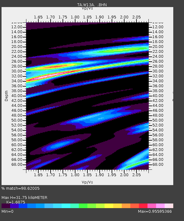
| Estimated Moho Depth: |
31.75 km |
| Estimated Crust Vp/Vs: |
1.69 |
| Assumed Crust Vp: |
6.276 km/s |
| Estimated Crust Vs: |
3.719 km/s |
| Estimated Crust Poisson's Ratio: |
0.23 |
|
| Radial Match: |
98.62005 % |
| Radial Bump: |
268 |
| Transverse Match: |
87.86873 % |
| Transverse Bump: |
400 |
| SOD ConfigId: |
2564 |
| Insert Time: |
2010-03-05 23:20:23.921 +0000 |
| GWidth: |
2.5 |
| Max Bumps: |
400 |
| Tol: |
0.001 |
|

Signal To Noise
| Channel | StoN | STA | LTA |
| TA:W13A: :BHN:20071129T19:08:36.525Z | 8.3308525 | 7.5762426E-7 | 9.094199E-8 |
| TA:W13A: :BHE:20071129T19:08:36.525Z | 11.152787 | 2.2798135E-6 | 2.044165E-7 |
| TA:W13A: :BHZ:20071129T19:08:36.525Z | 15.706099 | 4.8966635E-6 | 3.1176828E-7 |
| Arrivals |
| Ps | 3.7 SECOND |
| PpPs | 13 SECOND |
| PsPs/PpSs | 17 SECOND |


