You are here: Home > Network List > TA - USArray Transportable Network (new EarthScope stations) Stations List
> Station T25A Trinidad, CO, USA > Earthquake Result Viewer
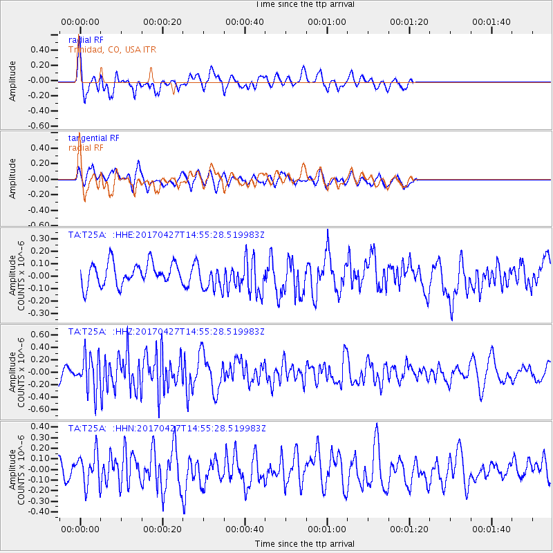
T25A Trinidad, CO, USA - Earthquake Result Viewer
*The percent match for this event was below the threshold and hence no stack was calculated.
| Earthquake location: |
Rat Islands, Aleutian Islands |
| Earthquake latitude/longitude: |
51.3/178.6 |
| Earthquake time(UTC): |
2017/04/27 (117) 14:46:33 GMT |
| Earthquake Depth: |
19 km |
| Earthquake Magnitude: |
5.7 Mww |
| Earthquake Catalog/Contributor: |
NEIC PDE/us |
|
| Network: |
TA USArray Transportable Network (new EarthScope stations) |
| Station: |
T25A Trinidad, CO, USA |
| Lat/Lon: |
37.14 N/104.41 W |
| Elevation: |
2017 m |
|
| Distance: |
54.5 deg |
| Az: |
73.026 deg |
| Baz: |
311.228 deg |
| Ray Param: |
$rayparam |
*The percent match for this event was below the threshold and hence was not used in the summary stack. |
|
| Radial Match: |
62.237194 % |
| Radial Bump: |
400 |
| Transverse Match: |
65.315094 % |
| Transverse Bump: |
400 |
| SOD ConfigId: |
11737051 |
| Insert Time: |
2019-04-27 05:13:09.395 +0000 |
| GWidth: |
2.5 |
| Max Bumps: |
400 |
| Tol: |
0.001 |
|
Signal To Noise
| Channel | StoN | STA | LTA |
| TA:T25A: :HHZ:20170427T14:55:28.519983Z | 2.7364416 | 2.8806662E-7 | 1.05270516E-7 |
| TA:T25A: :HHN:20170427T14:55:28.519983Z | 1.3045347 | 1.5983433E-7 | 1.225221E-7 |
| TA:T25A: :HHE:20170427T14:55:28.519983Z | 1.1729918 | 1.0507619E-7 | 8.957964E-8 |
| Arrivals |
| Ps | |
| PpPs | |
| PsPs/PpSs | |


