You are here: Home > Network List > US - United States National Seismic Network Stations List
> Station MNTX Cornudas Mountains, Texas, USA > Earthquake Result Viewer
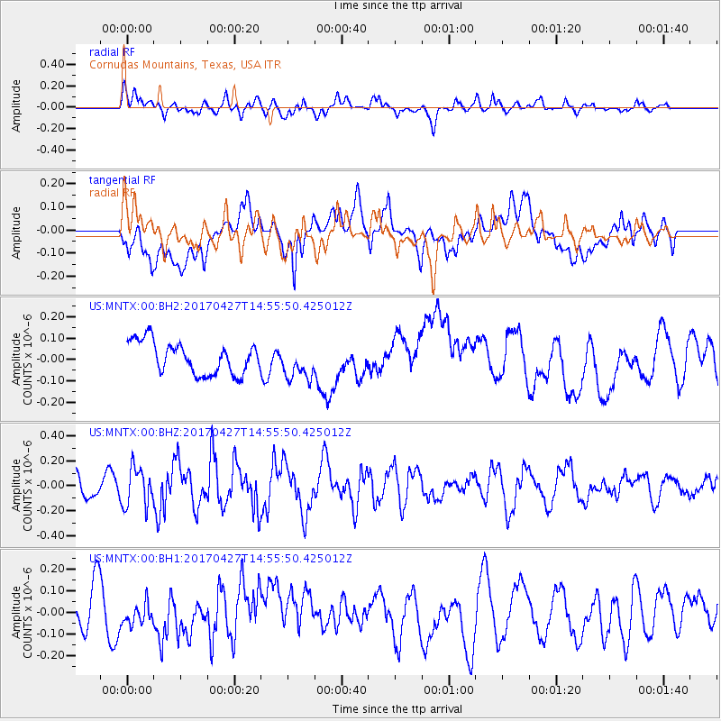
MNTX Cornudas Mountains, Texas, USA - Earthquake Result Viewer
*The percent match for this event was below the threshold and hence no stack was calculated.
| Earthquake location: |
Rat Islands, Aleutian Islands |
| Earthquake latitude/longitude: |
51.3/178.6 |
| Earthquake time(UTC): |
2017/04/27 (117) 14:46:33 GMT |
| Earthquake Depth: |
19 km |
| Earthquake Magnitude: |
5.7 Mww |
| Earthquake Catalog/Contributor: |
NEIC PDE/us |
|
| Network: |
US United States National Seismic Network |
| Station: |
MNTX Cornudas Mountains, Texas, USA |
| Lat/Lon: |
31.70 N/105.38 W |
| Elevation: |
404 m |
|
| Distance: |
57.6 deg |
| Az: |
78.506 deg |
| Baz: |
313.746 deg |
| Ray Param: |
$rayparam |
*The percent match for this event was below the threshold and hence was not used in the summary stack. |
|
| Radial Match: |
61.861458 % |
| Radial Bump: |
400 |
| Transverse Match: |
36.679558 % |
| Transverse Bump: |
400 |
| SOD ConfigId: |
11737051 |
| Insert Time: |
2019-04-27 05:14:00.718 +0000 |
| GWidth: |
2.5 |
| Max Bumps: |
400 |
| Tol: |
0.001 |
|
Signal To Noise
| Channel | StoN | STA | LTA |
| US:MNTX:00:BHZ:20170427T14:55:50.425012Z | 1.9850779 | 1.5536078E-7 | 7.826433E-8 |
| US:MNTX:00:BH1:20170427T14:55:50.425012Z | 0.54747593 | 4.724911E-8 | 8.630354E-8 |
| US:MNTX:00:BH2:20170427T14:55:50.425012Z | 1.0630006 | 7.903611E-8 | 7.43519E-8 |
| Arrivals |
| Ps | |
| PpPs | |
| PsPs/PpSs | |


