You are here: Home > Network List > UW - Pacific Northwest Regional Seismic Network Stations List
> Station MRBL Marblemount, WA, USA > Earthquake Result Viewer
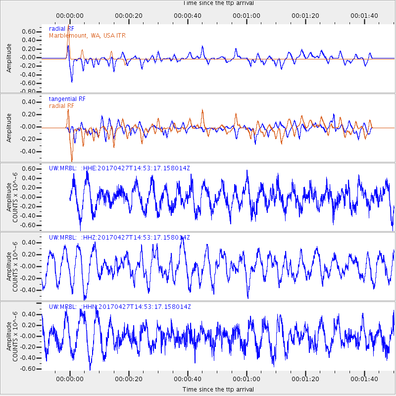
MRBL Marblemount, WA, USA - Earthquake Result Viewer
*The percent match for this event was below the threshold and hence no stack was calculated.
| Earthquake location: |
Rat Islands, Aleutian Islands |
| Earthquake latitude/longitude: |
51.3/178.6 |
| Earthquake time(UTC): |
2017/04/27 (117) 14:46:33 GMT |
| Earthquake Depth: |
19 km |
| Earthquake Magnitude: |
5.7 Mww |
| Earthquake Catalog/Contributor: |
NEIC PDE/us |
|
| Network: |
UW Pacific Northwest Regional Seismic Network |
| Station: |
MRBL Marblemount, WA, USA |
| Lat/Lon: |
48.52 N/121.48 W |
| Elevation: |
75 m |
|
| Distance: |
37.8 deg |
| Az: |
69.946 deg |
| Baz: |
297.401 deg |
| Ray Param: |
$rayparam |
*The percent match for this event was below the threshold and hence was not used in the summary stack. |
|
| Radial Match: |
52.032627 % |
| Radial Bump: |
400 |
| Transverse Match: |
48.76647 % |
| Transverse Bump: |
400 |
| SOD ConfigId: |
11737051 |
| Insert Time: |
2019-04-27 05:14:14.930 +0000 |
| GWidth: |
2.5 |
| Max Bumps: |
400 |
| Tol: |
0.001 |
|
Signal To Noise
| Channel | StoN | STA | LTA |
| UW:MRBL: :HHZ:20170427T14:53:17.158014Z | 1.7020415 | 2.7422627E-7 | 1.6111609E-7 |
| UW:MRBL: :HHN:20170427T14:53:17.158014Z | 1.6401004 | 3.1283386E-7 | 1.9074068E-7 |
| UW:MRBL: :HHE:20170427T14:53:17.158014Z | 1.0327526 | 2.355033E-7 | 2.2803455E-7 |
| Arrivals |
| Ps | |
| PpPs | |
| PsPs/PpSs | |


